September’s smoky days might seem long ago, particularly after the recent rainstorms. But it’s important to note that the U.S. wildfires this year demonstrated once again that the winds and weather that fan flames and spread smoke recognize no boundaries. They don’t blow along, then stop at the border to await customs and immigration approval.
Last month, southern B.C. endured choking smoke from fires in Washington and Oregon. At month’s end, a vast plume of smoke from California’s wildfires caused hazy skies here.
Satellite imagery for the month captured by the U.S. National Weather Service showed the fires’ smoke heading to and along the coast in mid-September, before sweeping abruptly eastwards on the storm front that cleared our skies. NASA’s Earth Observatory tracked plumes of soot, carbon monoxide and aerosols from the fires following a similar coastwards trajectory as far as five kilometres up into the atmosphere. At times, the smoke was so thick and widespread, NASA said it was visible from 1.5 million kilometres in space.
These patterns “are reminiscent of events of almost 118 years ago to the day,” says Steve Taylor, a Natural Resources Canada forest fire researcher who suggested I look into the September 1902 fires in the Pacific Northwest.
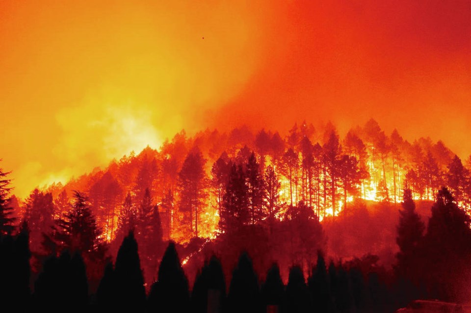
One of these, the Yacolt Fire — or Yacolt Burn, Yacolt Blaze, Yacolt-Cispus Burn, or Columbia Fire of 1902 — comprised dozens of devastating fires in western Washington and Oregon that burned 96,700 hectares between Sept. 8 and Sept. 12, 1902, and killed 65 people.
Winds from the interior blew ash from the fires to the coast, where it fell one centimetre deep in Portland. The smoke so enshrouded Seattle, 250 kilometres to the west, that street lights were needed at noon. Ships on the Columbia River were forced to navigate through the smoke by compass.
“Forty miles out at sea smoke from the Washington and Oregon forest fires, hangs in a dense wall over the water,” the Daily Colonist newspaper reported on Sept. 14, 1902. “Navigation is impeded, but so far no loss of life on the water has yet been reported.”
The day before, the newspaper had reported on fires on B.C.’s coast:
“The mountains across the Straits and those of Vancouver Island, are veritable furnaces, fires burning in every direction. From these came the heavy pall of smoke which hid the heavens yesterday and made night out of day.” [Copy errors are the paper’s own.]
Ash fell at the Outer Harbour and Oak Bay.
Details of specific island fires followed:
“For days there has been a big fire burning at the head of Koksilah river, across Shawnigan lake, and along the Saanich arm, and in Highland district the whole country is on fire, immense clouds of smoke arising.[…] A fire was still burning near Colwood, and there was a rumor yesterday that three houses at West Sooke had been destroyed, but this could not be confirmed, there being no communication, except by the stage, and the stage due yesterday has not yet arrived, being probably delayed by fire. At the [Malahat] Summit, on the line of the E. & N. railway, some three thousand cords of wood belonging to Mr. Deverne, of this city, is burning. Coming nearer home, there was a big fire burning all day yesterday on Admirals road, in the vicinity of the Naval hospital” next to the dry docks at the base.
As with this year’s fires south of the border, the region’s 1902 fires were fanned by strong winds from the east. These outflow events bring hot, dry air from the Interior towards the coast, raising temperatures to above normal, drying forests and undergrowth, and blowing sparks, ash and smoke.
“Maximum temperatures of 26.1˚C at Victoria Gonzales on Sept. 11 and 32.8˚C at Alberni Beaver Creek on Sept. 12, 1902, about 8 and 10˚C above the respective monthly normals, are suggestive of a regional scale outflow event at that time,” Taylor says.
A similar pattern occurred this year, with temperatures peaking at 29.1˚C on Sept. 7. By the next morning, smoke blanketed the coast.
“This not to discount the effects of climate change,” Taylor says. “In the present day, climate change is loading the gun, but outflow events often pull the trigger in the northwest.”


