Officials are keeping a close eye on the Ogden Point Breakwater as the enduring symbol of Victoria’s waterfront enters a second century of crushing waves, severe storms and potentially higher sea levels due to climate change.
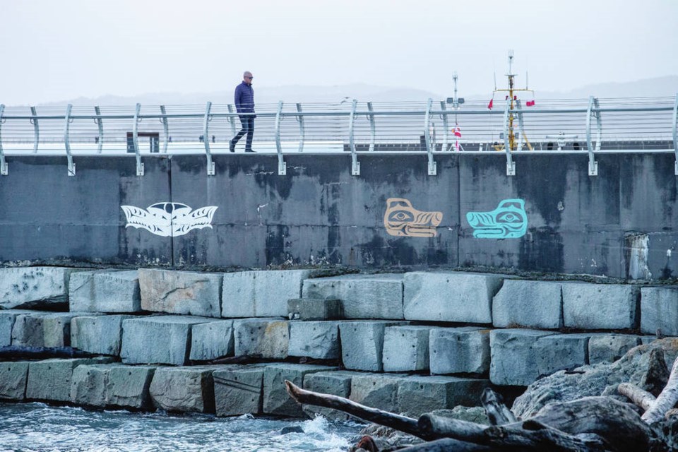
The 762-metre-long breakwater, built over three years and completed in 1917, is holding up well, but some of the granite blocks have been lifting and shifting under the sheer weight and action of the sea water and creating voids that could mean problems down the road.
Mark Crisp, head of infrastructure for the Greater Victoria Harbour Authority, said although there is no immediate danger to the integrity of the breakwater, sensor mapping surveys and video evidence from divers are providing a detailed look at the structure and areas where repairs might be needed now and in the future, as sea levels and wave activity react to changing weather patterns.
The breakwater is included in a comprehensive review of the harbour authority’s assets around the region — from Ogden Point to the Lower Causeway and Ship Point. The assessment of docks and piers as well as electrical, sewage and water lines, among other working parts, is expected to be completed for review by the authority’s committees and board of directors in March.
“Assessments for safety and operations are always being done, but this [report] has more of a forensic process to it,” Crisp said in an interview Wednesday. “The breakwater and piers at Ogden Point are over a century old. How are the metals holding up? We’re doing corrosion tests, chemical assessments of concrete.
“It sets a baseline for the true condition of facilities … this is where we’re at, and it tells us how much money might be needed in maintenance or replacement.”
The breakwater is one of the region’s most popular spots, attracting about 450,000 walkers each year.
It was an engineering marvel when it was built, at a cost of $1.1 million by the British firm of engineer Sir John Jackson, in anticipation of increased shipping along the Pacific Coast following the 1914 opening of the Panama Canal. Another breakwater, from Macaulay Point, was also planned, but never built.
More than a million cubic yards (765,000 cubic metres) of quarried rock was dumped into 30 metres of water to build a foundation for the breakwater, according to the Victoria Harbour History Society.
Then, more than 10,000 granite blocks, each weighing up to 15 tonnes and mined from Hardy Island east of Texada, were stacked on top in a nine-course pyramid.
It was capped with solid concrete to form a walking path, which extended its life, said Crisp, as concrete reinforced with steel would have likely started “rust-jacking” and weakening the structure years ago.
A detailed Linar mapping using laser ranging and GPS technology, as well as diver assessments underwater, has enabled the harbour authority to flag areas of concern, such as widening gaps in the blocks due to “hydraulic lift.”
Those areas are near the bend in the breakwater and in the final 800 metres toward the lighthouse, where the structure is exposed to higher wave action, said Crisp.
He said small repairs, such as grouting patches and shifting blocks, have been made, but nothing at this point is causing any concern about safety. Measurements of gaps and anomalies form a baseline, as the breakwater endures increasing storm events, Crisp said.
“We are looking at the trending of how the sea is acting against the structure, and will it be sufficient in the future to resist something much more destructive,” he said. “We will do repairs fundamentally, but at the end of the day, we are also looking at a much longer game plan.”
Also included in the plan is a detailed inventory of the condition of the rails installed in 2014. The maritime-grade steel wires and tension bolts are showing some signs of rust, as expected, said Crisp, and those are gradually being replaced as needed.
Crisp’s overall facility assessment also shows everything underground at Ogden Point, which was built from fill over the past century. That includes every pipe and wire under every inch of blacktop supporting the cruise-ship terminal and piers.
Ogden Point over the years has been home to grain silos, lumber mills and fish processing. Future plans include enhancing the area as a cruise terminal, with potential for a commercial district and hotel.
Assessments of the fuel dock at Fisherman’s Wharf and the Broughton Street Pier downtown have already revealed structural problems. While they’re still operational, they have weight restrictions and limited use.
The harbour authority has postponed improvements amid the pandemic, which has forced the cancellation of cruise-ship arrivals, which bring in about 70% of the authority’s revenue.


