Update: A wind warning is in effect for Greater Victoria for Saturday morning. Winds could reach 70 km/h in areas near Juan de Fuca Strait, Environment Canada said. The winds are expected to ease later Saturday.
- - -
Strong winds led to a major round of ferry cancellations Friday afternoon and evening between Swartz Bay and Tsawwassen.
B.C. Ferries spokeswoman Tessa Humphries said the decision was made in the mid-afternoon after discussions with Environment Canada weather experts.
She said Friday's 4, 5 and 7 p.m. sailings from Swartz Bay were cancelled, along with the 5, 6 and 7 p.m. departures from Tsawwassen.
“The storm, as per Environment Canada, is expected to shift to down here and the wind speeds will be too high,” Humphries said. “We anticipate the 9 p.m. in both directions resuming.” [Update: Spirit of British Columbia left at 9:01 p.m. Friday night from Swartz Bay for Tsawwassen, and Spirit of Vancouver Island left at 9:02 p.m. from Tsawwassen for Swartz Bay. Both sailings were full, and were the last ones scheduled for the day.]
Service resumed on the Horseshoe Bay-Departure Bay run after a number of cancellations earlier in the day.
“The weather conditions have improved up there,” Humphries said.
Here's a roundup of other storm information:
Weather
Winter storm, snowfall, wind and rain warnings remain in effect for northeastern and north-central B.C., most coastal areas, much of Vancouver Island and a section of eastern B.C.
Rainfall warnings are in place for parts of the Island. Between 100 and 150 millimetres of rain was expected on west Vancouver Island and near Port Alice on the north Island. Up to 50 mm could fall on the Island’s east coast.
Environment Canada warned of possible flooding in low-lying areas and washouts near rivers, creeks and culverts.
Wind warnings were issued for Greater Victoria, the Gulf Islands, and the east, west and north Island, with gusts of 70 km/h expected.
Christmas decorations still up? Might be a good idea to bring inflatable Frosty inside. Wind Warnings are in effect for winds up to 70-80 km/h around the South Coast starting this afternoon!
— ECCC Weather British Columbia (@ECCCWeatherBC) January 3, 2020
Details: https://t.co/hLccVOk39R #BCStorm pic.twitter.com/FP2vywOBty
The storm is expected to bring up to 150 millimetres of rain to parts of Vancouver Island.
Heavy rain hit Vancouver Island late Thursday morning, with strong southeasterly winds developing in the afternoon.
Higher elevations received some snow, but evening warm air was expected to change all precipitation to rain.
B.C. Ferries
B.C. Ferries cancelled several sailings Friday due to heavy rain and high winds. You can see the full list here.
There sailing cancellations Friday between Tsawwassen and Duke Point, Horseshoe Bay and Departure Bay, Comox and Powell River, Cortes Island and Quadra Island, and Campbell River and Quadra Island.
Happy Friday and safe travels! It's a little boisterous out there this morning, as sailings have already been cancelled due to the high winds. If you're travelling, I recommend viewing our #ServiceNotices to see if your route is affected here: https://t.co/IwYPdp0WfS ^js
— BC Ferries (@BCFerries) January 3, 2020
The Tsawwassen-Duke Point cancellations included the 10:15 a.m. sailings from both Tsawwassen and Duke Point, and will also include the 12:45 p.m. sailings from both terminals.
On the Horseshoe Bay-Departure Bay route, six morning cancellations are being followed by 1 p.m. cancellations from both terminals.
B.C. Hydro
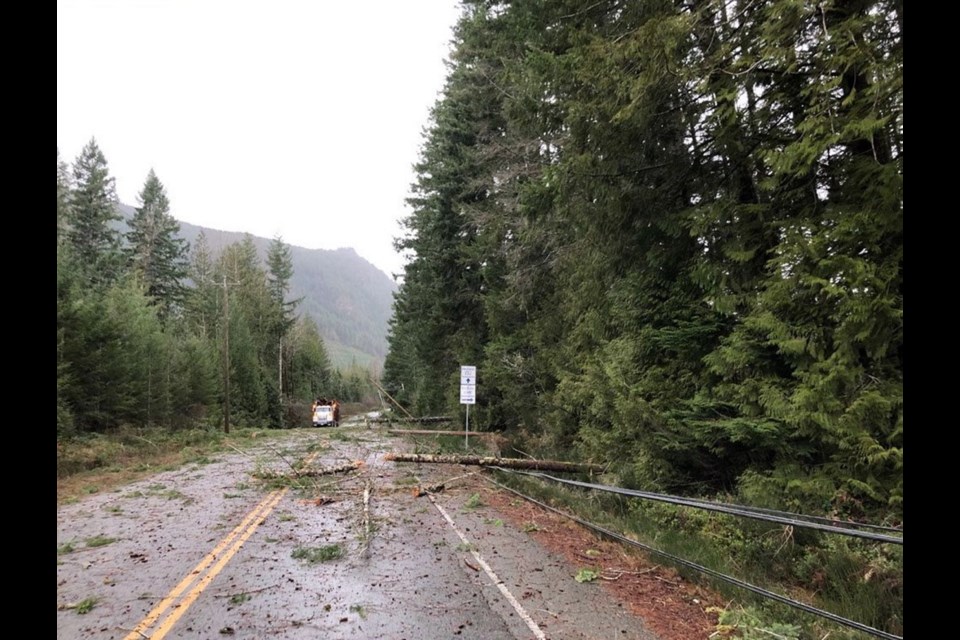
B.C. Hydro was bracing for outages across the south coast while crews continue to restore power to several thousand southern Interior customers left in the dark after a New Year's Eve snowstorm.Downed trees blocked roadways around Lake Cowichan.
Here's a quick look at some of the #BCStorm damage crews are facing out there today on #VancouverIsland - some damaged lines and fallen trees near #LakeCowichan. Remember - if you see a fallen power line, it's an emergency. Dial 9-1-1. pic.twitter.com/YfHYGNjiPb
— BC Hydro (@bchydro) January 3, 2020
We're also preparing for possible damage from a windstorm that is forecast to hit #VancouverIsland and the south coast today and tomorrow. We're encouraging customers in these areas to prepare for potential power outages: https://t.co/Kyflz96l0E #BCStorm pic.twitter.com/LT7hFGAwk0
— BC Hydro (@bchydro) January 2, 2020
As of 2:45 p.m. Friday, approximately 4,500 customers in the Ucluelet and Tofino areas were without power. B.C. Hydro said crews were patrolling the transmission line to find the outage cause.
Other outages have been reported, as well:
A crew will be heading to an outage affecting 2,300 customers in the #Courtenay and #QualicumBeach area. Updates will be posted on our outage site: https://t.co/WgKDAjKHmM pic.twitter.com/nzsv7Ey52v
— BC Hydro (@bchydro) January 3, 2020
See B.C. Hydro's outage map here.
Roads
There were reports of trees across roads on Friday, along with pooling water on highways.
CLOSED - #BCHwy19A - Closed at Mystery Beach Road between Union Bay and Buckley Bay while BC Hydro crews remove a fallen tree from power lines. Expect delays. #VanIsle
— DriveBC VI (@DriveBC_VI) January 3, 2020
UPDATE: South Shore Road work continuing #tree removal from roadway, single lane alternating traffic is under the direction of #traffic control. Proceed with caution & watch for workers ♂️#shiftintowinter #bcstorm #lakecowichan #mesachie @bchydro @LakeCowGazette @DriveBC_VI
— Emcon Services Inc., South Island Division (@EmconSouthVI) January 3, 2020
Parks
High winds also prompted Parks Canada to issue a wave hazard advisory for beaches, shorelines and coastal waters in and around Pacific Rim National Park Reserve.
It warned of wave surges, strong currents and shoreline flooding, and urged visitors to avoid activities in the water.
Wave Hazard Advisory issued for Pacific Rim National Park Reserve, Dangerous Waves, Strong Currents and Possible Upper-shoreline Flooding – January 3-4, 2020. https://t.co/QbMca8sX6i pic.twitter.com/667WNamSt8
— Pacific Rim NPR (@PacificRimNPR) January 2, 2020
Homeless shelters
In Victoria, the Emergency Weather Protocol was activated for a second day, making extra beds available at local shelters on Friday night.
JAN 3 – Victoria EWP has been ACTIVATED. For current shelter information: https://t.co/guS5S6nxv6 #yyjewp #yyj
— Victoria EWP (@Victoria_EWP) January 3, 2020
Elsewhere in B.C.
The storm was expected to intensify as it carries snow and rain across the province.
As much as 90 mm of rain was forecast over Howe Sound and Metro Vancouver, along with a chance of wet snow.
The central and southern Interior were expected to get snow Thursday evening, but freezing rain could hit the central Interior as the storm pushes northward.
The weather office said north central B.C., from Terrace and Kitimat east to the Alberta boundary, could see 20 to 30 centimetres of snow.
— With files from The Canadian Press


