As Vancouver Islanders pack away their snow shovels with the return of above-freezing temperatures, some people are grabbing sandbags as another winter storm is forecast to hit, bringing high winds, heavy rain and high tides.
On the heels of a Monday windstorm that knocked out power for thousands, a wind warning is in effect for the south Island from this morning through to the evening. A special weather statement on the risk of coastal flooding in low-lying areas is in place for East Vancouver Island, Duncan to Campbell River, and the Southern Gulf Islands.
Environment Canada is forecasting southeast winds of 70 gusting to 90 km/h for areas adjacent to Haro Strait in the morning shifting to westerly winds over Greater Victoria tonight.
High winds may toss objects or result in fallen tree branches and power outages, warns the weather forecaster.
A king tide or very high tide is forecast to accompany the wind this morning. Environment Canada is warning of swells and enhanced waves along the Strait of Georgia that could lead to flooding, debris washing ashore and damage to infrastructure.
“There is a high confidence of coastal flooding near the Strait of Georgia near high tide Tuesday morning,” Environment Canada said.
“These water levels can cause damage to coastal infrastructure in low lying areas, especially at locations prone to impacts during similar events in the past. East to southeast facing coastline may see larger waves and higher localized flooding.”
The special weather statement also applies to Metro Vancouver including Burnaby, Surrey, Richmond and Delta as well as Howe Sound and the Sunshine Coast.
In Vancouver, portions of the Stanley Park seawall will be closed today. Significant damage was done to the walkway after a king tide hit on Jan. 6.
Victoria is forecast to see up to 20 mm of rain overnight Monday into today and more rain —about 5 mm — during the day.
Nanaimo is expected to see up to 25 mm of rain overnight with five to 10 mm today. Temperatures on Vancouver Island are forecast to remain above freezing for the week.
On Monday, the Transportation Ministry reported Crofton Road was closed in both directions due to flooding between Crofton and Chemainus roads. The road was re-opened just before 7 p.m.
North Cowichan issued a statement advising residents to use the Trans-Canada Highway and avoid Chemainus Road due to localized flooding.
The district also issued an evacuation alert “because of the potential danger to life and health” for specific areas related to expected high water levels near rivers and coastal areas created by melting snow, increased river flows, and storm surges at high tide.
The evacuation alert — a warning of a potential order — is in effect for: Chemainus Road, east of Halalt First Nations and South of Ashcroft Road; Crofton Road, north of Tsussie Road; Swallowfield Road; and Amos Road, south of Ashcroft Road. The alert with specific addresses can be found here.
Those under the alert are asked to prepare in the event of that an “evacuation order” is issued by packing essential items for quick departure, make plans to help people with disabilities, to prepare to move animals and livestock, fuel vehicles, and monitor media and the district’s website called Cowichanalert.ca for updates. In the event of an evacuation order, reception centre locations will be made public.
North Cowichan residents have also been asked to clear storm drains and check eaves and downspouts to avoid flooding due to heavy rains combined with snow melt. Sandbags and sand are available for residents at Russell Farms, 2711 Mt. Sicker Rd., and the Cowichan Valley Regional District Bing’s Creek Recycling Centre, 3900 Drinkwater Rd. Resident must bring their own shovels.
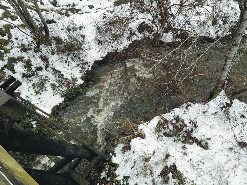
Other known areas where creeks and streams can be expected to overflow in North Cowichan include: Mary Street/Philip Street, Rosewood Avenue, and Seine Road.
Andrew Gaetz, operations manager for Emcon Services which maintains South Vancouver Island and Gulf Islands highways, said by Monday most roads were clear of snow from last week’s storm with some exceptions.
“There’s still the occasional side road that is being sanded and plowed but the warm weather has washed away most of the snow,” he said. The main concern now is localized flooding, mainly in the Cowichan Valley, he said.
Meanwhile, B.C. Hydro crews had another busy day Monday after an overnight windstorm saw nearly 15,000 customers without power on the South Island in the morning. That was down to about 8,000 customers around noon and 1,200 at 6 p.m.
Pockets of outages remained in Victoria, the Saanich Peninsula, Duncan, and several Gulf Islands. The majority of outages were attributed to high winds and downed wires, trees and poles.
>>> To comment on this article, write a letter to the editor: [email protected]


