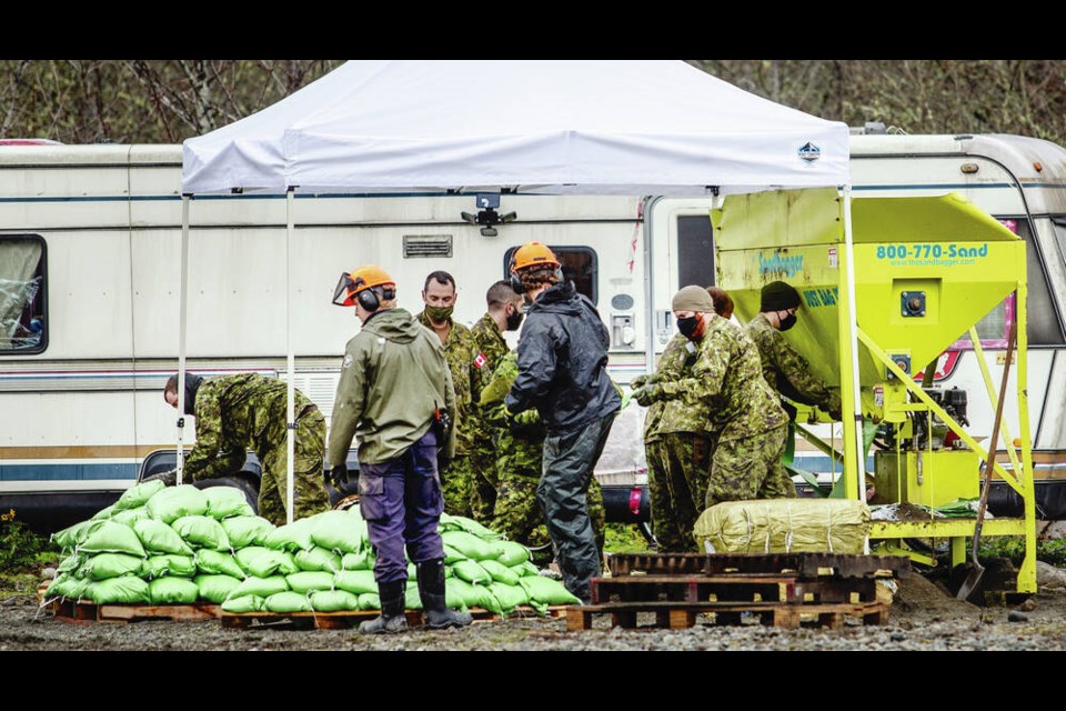
Canadian Forces members were shoring up vulnerable areas of Cowichan Tribes land with sandbags Tuesday, to protect homes in the First Nations community from the rising Cowichan River, as the latest heavy rainstorm hit the province.
About 100 homes on the First Nation were affected by flooding in the Nov. 14-15 rainstorm.
Tribes members have been offered free self-sandbagging services, and advisories have been posted to prepare “grab and go kits” including medication and important papers, as well as to unplug all appliances in basements and crawl spaces in case of more flooding.
The latest rainstorm, the third of three atmospheric rivers, could be the worst yet for parts of B.C., Public Safety Minister Mike Farnworth said in an update on the province’s efforts to manage flood and storm damage.
In the hardest-hit areas, the storm could be at least as forceful as the one in mid-November that caused significant flooding and road damage, he said.
“In some areas, such as the central coast, this could be the most intense storm yet.”
Environment Canada warned of extreme rainfall that could worsen existing flooding, or cause new flooding on already saturated ground.
Armel Castellan, a meteorologist with Environment Canada, said the central coast and the west coast of Vancouver Island could see up to 150 millimetres of rain, with up to 120 mm in the Bella Coola area, while the flood-soaked Fraser Valley east of Abbotsford could get up to 80 mm.
David Campbell, head of the B.C. River Forecast Centre, said flood watches are in effect for Vancouver Island, the central coast, south coast, Fraser Valley, Fraser Canyon, and some interior watersheds.
Campbell said they were also watching water levels in the Nooksack River in Washington state, which contributed to flooding in a prime agricultural area of Abbotsford last month. The river’s water levels had dropped over the weekend, but the coming rain could push it back up, he said.
Five hundred Canadian Armed Forces members have been deployed to areas of concern, including on Vancouver Island.
19 Wing Comox is also ready to assist, as is CFB Esquimalt, said Farnworth, who urged British Columbians to avoid non-essential travel and “wait out the weather.”
“Also — and I can’t emphasize this enough — please follow the directions of your local government,” he said.
If an evacuation alert or order has been issued for your area, take it seriously, he said. Those unable to evacuate should call 911 and report their location.
Emergency Management B.C. and “an army of local government staff and community volunteers” are ensuring shelter, food, medication and other resources are available to those in need, said Farnworth.
As well, sandbags, emergency kits, livestock feed, fuel and other supplies are being provided.
“We’re co-ordinating additional supports and services from the federal government, as well as non-governmental organizations and industry,” he said.
Portions of roads and highways — including Highway 1 between Chilliwack and Abbotsford as well as a stretch east of Chilliwack between Hope and the community of Popkum, and Highway 99 between Pemberton and Lillooet — were closed across the province as a precaution, or passage was restricted to commercial vehicles only.
B.C. Transportation Minister Rob Fleming asked all drivers not to be on roads and highways unless their travel is “absolutely necessary,” warning commercial truck drivers might be taking unfamiliar alternate routes because of road damage from the Nov. 14-15 storm.
“Please be patient and accept it will take longer and drive according to current conditions,” he said.
Fleming said many of the restrictions are short term. “We will get though this,” he said.
“We’re monitoring conditions across the province, including the mid and south coast, the Interior and the north part of Vancouver Island.
“Crews and equipment are ready to be deployed in all of those areas as needed.”
The rain should mostly ease on Thursday and Friday, Castellan said, though a smaller system is expected to affect the south coast late on Friday.
“We don’t expect large, large quantities, but we will be keeping a very close eye on the continued barrage of storms affecting the B.C. coast as we go into next week.”
Avalanche Canada warned Tuesday of an “increasingly dangerous avalanche cycle” in many of B.C.’s mountain ranges.
It rated the risk as high to extreme on the south and northwest coast and in eastern B.C. from Chetwynd south to Castlegar.
People should stay clear of avalanche terrain because avalanches were “expected to run full path to valley bottom with the arrival of this third atmospheric river,” it said.
— With files from The Canadian Press


