On the beach at Ebey's Landing, grey bones of driftwood that have washed up from who-knows-where have been cobbled into elaborate beach shelters to be used for who-knows-what. Just knowing someone spent time constructing them makes you smile.
In the 1890s, pilings anchored fish traps along this shore. These days the traps and pilings are gone, but anglers still frequent a narrow crescent of sand with a wide, crane-your-neck view of open saltwater where scuttling ferries and lumbering container ships thread the waters of Admiralty Inlet and the Juan de Fuca Strait.
Watching surf-casters woo coho adds to the sense of continuity that washes over visitors here to Ebey's Landing National Historical Reserve.
The landing, a timeless spot where a broad swath of fertile prairie meets the sea, is a fine place for a hike any time of year - for history, for scenery and for fresh salt air.
This is where Col. Isaac Ebey, formerly of Missouri, came to stake a claim in 1851. Among the first Euro-American settlers on Whidbey Island, he liked it so much he coaxed more of his family to move here.
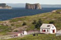
The exposed and often windy beach was the island's first ferry landing, where Ebey brought supplies ashore and a ferry took passengers across to Port Townsend - you can see it from here - and south into Puget Sound.
At the foot of Ebey Road, which curls steeply down a bluff to the beach, a small state-park wayside is the trailhead for two delightful hikes. The first stretch for both starts by climbing 57 stairs back to the top of the bluff, then follows the blufftop alongside farmed fields, recently cultivated with beets next to a golden patch of mowed hay.
To the left is that saltwater view, looking across to Point Wilson lighthouse, Protection Island and a backdrop of the Olympic Mountains. To the right, look past old farmhouses and barns to Mount Baker. Above, watch for bald eagles wheeling high on updrafts.
It's a very gentle uphill grade for half a kilometre to a split rail fence and a turnstile, where paths diverge.
Straight ahead and up a steep hill, heading to the 80-metre crest of the bluff, the trail enters the Robert H. Pratt Reserve, belonging to the Nature Conservancy.
"There's a gorgeous view from up there," Mike Price told me as he hiked down with companion Debra Ante-tomaso, both of Oak Harbor, with dog Jake, a German shorthair.
The trail continues as part of a 5.6-kilometre loop that switchbacks down to a pretty lagoon, Perego's Lake, a shorebird haven, before hikers follow the beach back to the trailhead.
My wife, Barbara, and I took Price's word for it, and turned right. Our objective was the path less taken: a 4.3-kilometre round trip to Sunnyside Cemetery.
We were intrigued to see the grave of Isaac Ebey, who only six years after settling here was beheaded by a raiding native tribe from what is now British Columbia, taking vengeance for the death of a chief at the hands of Americans near Port Gamble.
"The lagoon walk is clearly the traditional sort of loop that people do," Mark Preiss, Historic Reserve manager, told me. "But that cemetery - when people want to learn about the homestead families, that's the place. Thomas Coupe (for whom nearby Coupeville is named) is buried in that cemetery. The Ebeys are buried in that cemetery. For many, many Whidbey Island place names, you can find the family names in that cemetery."
We followed a wire fence bordered by puffball seedpods of thistles and skirting the upper edge of the farm prairie, about 45 metres from an upland fir-and-cedar forest. Sounds of honking geese and lowing cattle blended with the lapping of shore waves behind us. Straight ahead, snowy Mount Baker was our beacon.
After an 800-metre walk, where some modern homes edge the prairie, we angled left through an opening in the fence to inspect the restored 1850s home of Jacob Ebey, Isaac's father, who followed him from Missouri. There's also an old blockhouse, built as protection against raiding tribes. June through September, the house is staffed by volunteers as a Historic Reserve visitor centre.
From here, no signs point the way, but we proceeded straight on a gravel track past another beet field and along a hedge of snowberry and rosehips, then wound to the right to easily find the cemetery.
The Ebey plot, surrounded by a white picket fence near the cemetery's edge on Sherman Road, includes weathered old monuments for Isaac, Jacob and more.
As Preiss promised, we found Coupes, Libbeys and other names from around the island. One small tombstone with the name broken off listed an age of "1 yr., 1 mo., 7 days," with the inscription, "Sleep on, dear Freddie, and take your rest. God called thee home, when He thought best." Nothing like a graveyard to put you close to people's loves and losses.
It's an easy tramp back, with that panoramic view to remind you what made settlers come here in the first place. And why they stayed.
IF YOU GO:
Where: From Highway 20 at Coupeville, Whidbey Island, go south on Ebey Road about 2.4 kilometres until the road dips to the beach. Park in the small state-parks wayside (Discover Pass required) or on the road shoulder along the beach (free). The trailhead is just beyond a vault toilet at the state wayside.
Map: Maps and brochures for the historical reserve, which takes in 17,400 acres of Central Whidbey Island, are available at Island County Historical Society Museum, next to the Coupeville Wharf.
More information: Ebey's Landing National Historical Reserve, nps.gov/ebla or 360-678-6084.