“Caution Steep rugged terrain Slippery cliff sections Avalanche conditions exist Use at own risk” was the trailhead sign’s crisp announcement at the beginning of the hike to Kings Peak in the northern reaches of Strathcona Provincial Park.
So … we knew what we were up against — sort of. From our first boot steps, the trail went straight up and then, once under a power line, tipped up even more severely. (I’ve mostly used the descriptor “hike,” although “climb” would be more apt in many parts of the route.)
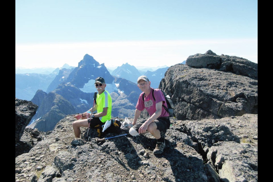
We were three – guys, all in our mid- to late-70s, highly fit and well experienced in the mountains of several countries, but what we were about to encounter was, as they say, a trifle more than we’d bargained for.
In Lindsay Elms’ book on the history of climbing on Vancouver Island, Above the Bush, he tells of two world-renowned climbers, Doug Scott from Great Britain and Australian Greg Child, coming to Strathcona’s peaks and declaring: “It’s remote here and there aren’t facilities. The challenges are comparable with anywhere… .”
Not that we were attempting anything like the climbing they did, but it does show that our Island mountains should not be understated nor undervalued for their difficulty.
Kings Peak (apostrophe optional) is a doubled-peaked affair with the higher peak, Kings Peak, at 2,065 metres and the lower, Queen’s Ridge, a hundred metres or so below it. (For the salaciously minded, you might say you have to mount the Queen to sit on the King’s throne. But we won’t go there.)
The mid-September sun was warm as we spent four hours hiking the unrelenting steep switchbacks, then navigating numerous rooty, rubbly and rocky short scrambles. Though not too difficult, they were certainly hard work and sent the heart rate up and the perspiration flowing, and made our 30-pound packs stick to our backs. A couple of creeks with their still-tumbling waterfalls were easy to cross, their clear and effervescent waters slacking our thirst.
We were heading for an alpine meadow where we would set up camp as a base for the next day’s summit climb. But the meadow had an obstacle — a multi-level waterfall the banks of which we had to scramble up with aid of three sections of rope, and an exposed cut-bank to traverse — without rope!
We grunted up all of it with no mishap — well, perhaps my fingertips were getting a little frayed. It was definitely the most testing of the day’s route.
Another creek crossing and up a short tufted rise and we were at the meadow. Choosing a good campsite was not a problem. A good meadow of the alpine sort, it had ample flat grassy areas set among stunted fir, hemlock and a few spruce.
We chose a spot next to a large boulder — ideal as a large dining table and for placing our gear. The meadow was, in fact, a bowl, the walls of which rose a hundred metres on three sides.
Over the south wall spilled a glorious waterfall. At its base was a small snowfield through which the spilling waters created an ice cave. The west wall was to be our route to a ridge that led to Kings Peak. It looked intimidating — nothing more than a narrow but long fissure in the rock wall.
How the heck to get up that? But ah, we’d have our light day packs.
Climbing and hiking law has it you don’t know how difficult a climb or scramble is until you put your nose to the rock. That was exactly the case the next morning, as we met the almost perpendicular fissure or gully, as the map termed it.
The almost 50-metre-high obstacle was definitely a challenge — not much to hold onto except roots and foliage. The last few metres were, although the steepest, the safest part of the climb — a solid rock face with secure holds and ledges.
Emerging onto a flattish plateau, we could see Queen’s Ridge rising to our left, with Kings Peak looming beyond.
The route up and over “The Queen” was well marked and easy to follow. Mounting “The Peak” demanded some route-finding, although well-placed cairns were definitely helpful.
Because there’s no vegetation to speak of high on the mountain, the exposed rock has, over time, become rubble in parts and therefore unstable underfoot.
We were glad of the rock face and its more secure hand and foot holds, despite the occasional sections of exposure.
After three and a half hours of climbing, we were on the summit.
Greeting us, seemingly a stone’s (or boulder’s) throw away, was the visually stunning Elkhorn Mountain, Vancouver Island’s second-highest mountain.
As its name implies, its pyramidal form is reminiscent of the Swiss/Italian peak the Matterhorn. (To its left, and a few kilometres away, we could see the Island’s highest peak, the Golden Hinde.) Mount Colonel Foster was also in full view, its multi-jagged peaks guarding the aquamarine-coloured Landslide Lake at its base.
(These three peaks are all within 60 metres high of each other: Golden Hinde at 2,195 metres; Elkhorn at 2,194 metres and Colonel Foster at 2,135 metres.) In all directions, the dark and white hues of mountains, snow and glaciers filled the skyline.
We could even see the Coast Mountains. In the still air, we ate our lunch and drank in the almost overwhelming sights surrounding us. How more fortunate could we be?
Getting off the mountain was just as demanding as mounting it.
We gingerly retraced our route using all the caution we could muster. While we met only eight people on our way up the mountain (six of those on their way out), on our way out, we met more than a dozen coming in.
We’d chosen a mid-week, three-day trip, hoping to have the place to ourselves — selfish souls that we are — which, by and large, we did.
John Crouch is a Victoria author. His guide books, Walk Victoria, Hike Victoria and Bike Victoria, are local bestsellers


