Crowds gathered excitedly at high tide Wednesday morning to watch the waves and wind lash the Tsawwassen waterfront in Boundary Bay, but Delta municipal officials reported no further major breaches of residential seawalls.
"I think we've seen the worst of it now," Dave Halliday, deputy director of engineering operations, said at 9:30 a.m. as ocean spray rained upon his head. "But we might be back again tomorrow."
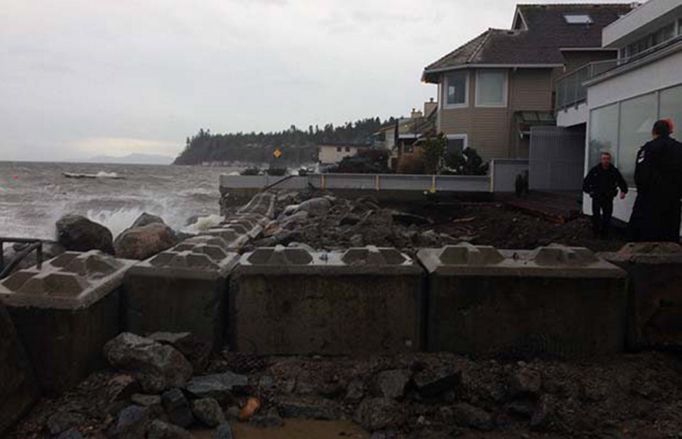
Halliday stood at the foot of Seaview Road where the waves took out a portion of seawall Tuesday at about 8 a.m. forcing the evacuation of one residence. Municipal crews worked until 9 p.m. to create a barrier of concrete blocks to prevent the waves from undercutting the home.
Elsewhere along the waterfront communities of Boundary Bay and Beach Grove a combination of sand bags and sand berms were located at vulnerable spots, including public access paths to the beach. The municipality has increased its vigilance in the area since flooding in February 2006 and has established better standards for seawalls for new homes, he said.
In the background, kite boarders took advantage of the strong winds, navigating their way around large logs tossed about by the sea. Residents braved the conditions to take photos and videos.
"This is exciting," said Susan Frank, who lives two blocks away on 67A Street, overlooking a lagoon created by the storm. "In summer, this is all sand — barbecues and picnics."
She gave Delta municipality credit for working to keep the community safe, adding that her immediate neighbours, including seniors, are talking about a shared safety plan. "Nothing brings a community together more than a storm," she said.
Chris Dowsett lives in Ladner but came down to check on a family home one block from the beach on Centennial Parkway that his grandparents bought in 1944. The storm made him a bit nervous about the potential for flood damage not covered by home insurance.
"It'll cover sewer backup, but this is a little more than sewer backup," he said with a smile.
A high tide of 4.5 metres, not counting storm swells, occurred in Tsawwassen at 8:45 a.m.
Meanwhile, the Vancouver parks board says the lack of high winds has helped lower the danger of flooding Wednesday at Locarno Beach.
Parks manager Malcolm Bromley said the crest of the king tide arrived at around 9 a.m. without over splashing the beach area.
Parks cruise had sandbagged a long stretch of NW Marine Drive along Locarno Beach in the event that flooding reach the road and residences across the street.
Although the danger has passed, parks director Bill Harding said the sandbags will remain in place until after Christmas because the next high tide of concern will arrive on Christmas day.
A number of citizens curious about the potential for flooding came down to the park but left disappointed by the lack of action.
Some low points in the park have standing water, which has attracted a number of waterfowl. But the potential for a civic disaster appears to have passed.
The storm did force B.C. Ferries to cancel the 10:30 a.m. and 12:30 p.m. sailings to and from Horseshoe Bay to Departure Bay in Nanaimo due to stormy weather.
B.C. Ferries earlier cancelled the first two round trips between Comox and Powell River and the ferry is holding in dock at Little River, Comox due to severe weather.
Highway 3 near Keremeos remains closed in both directions due to another rock slide and no time for reopening has been issued.
Meanwhile, glooding in Courtenay led Mayor Larry Jangula to declare a state of emergency on Tuesday. The city closed streets and trails in low-lying areas as well as the Lewis Park recreational facility. On Monday, 100 millimetres of rain fell above the Comox Valley reservoir and between midnight to 7:30 a.m. Tuesday another 82 mm fell. With up to 70 mm more forecast for today, Courtenay is bracing for the flooding to worsen.
Emergency Management B.C. and B.C. Hydro said the risk of flooding will continue through Thursday. The flooding could eclipse devastating floods that occurred there in 2009 and 2010, a city of Courtenay spokesman said.
Jangula said the state of emergency was a necessary precaution that will allow authorities to order travel bans or evacuations.
From Fanny Bay to Courtenay, parts of the Inland Highway became hazardous because of water pooling. Flooding forced the closure of Courtenay’s Fifth Street bridge, with traffic stretching two kilometres.
In Port Alberni, residents reported flooding in basements and thousands lost power. Municipal crews blocked off lower Third and Fourth Avenue, where flooded business owners scurried to deal with surging rainwater as storm drains overflowed. Wind tore the roof off Tar’s Auto Sales on Third Avenue and floodwater forced staff to evacuate.
Port Alberni Fire Department Capt. Herb Nadig said: “Lots of trees down, trees on the power lines.” Firefighters cordoned off areas where power lines were down and told residents to stay inside.
B.C. Hydro said wind knocked out power to about 11,000 customers in the north Island and nearly 4,000 in the south Island. By Tuesday night, power was back for most south Island customers, but hundreds were still without power further north.
It was expected to take until 4 a.m. today to restore power in Port Alberni, said Karla Louwers, spokeswoman for B.C. Hydro. Wind knocked trees onto power lines and caused many to fall, she said. “There’s multiple sources of damage.”
Flooding delayed B.C. Hydro crews by forcing them to take detours to get to trouble spots, Louwers said.
Rain will continue today in Greater Victoria with 25 to 35 mm expected, mostly between midnight and noon, said Doug Lundquist, an Environment Canada meteorologist. “A third storm may roll in Thursday. But by Friday, the whole system kind of passes.”


