Victoria Coun. Sharmarke Dubow recently challenged his fellow councillors, transit officials and Victoria Regional Transit Commission members to use public transit as their only method of transportation for a week. In his Nov. 7 motion to Victoria council, he argued that those responsible for providing transit services to Victoria residents should experience the services first-hand.
Everywhere, decisions that affect local residents are made by small numbers of people far away and with constrained insight into the effects of those decisions on day-to-day functioning of people’s lives.
I observed the effects of this recently when I walked with a friend through her area of Saanich. The six-kilometre route wound from Panama Flats through Strawberry Vale and Marigold communities, across the highway and down to the Gorge Waterway, before circling back to Colquitz Creek trail.
As we walked, we stopped for coffee on Gorge Road, and my friend checked her post box at Tillicum Plaza, picked up a prescription at Tillicum Mall, and paid some bills at Burnside Plaza.
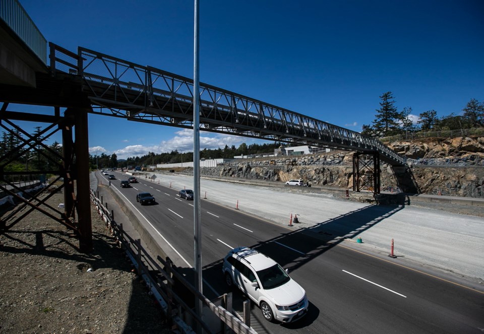
We also checked out how the McKenzie interchange was coming along. The pedestrian bridge over the highway by Spectrum Community School provides a front-row view — for now. Located west of the interchange, a bridge has connected the three schools on the north side — and the Marigold and south Strawberry Vale communities — to the Gorge Tillicum area for decades. During the past couple of years, a temporary structure has stood at the old crossing and, according to interchange plans, the entire structure will be removed in the coming year.
When that happens, the way people move through and between these communities on foot will change dramatically. When the bridge comes down, most pedestrian traffic across the highway on the three-kilometre stretch between Helmcken and Interurban roads could well end.
There’s no provision for street-level crossings at the interchange itself. Bike and foot traffic on the highway’s north side will be diverted to the Goose and a new cycling overpass over the highway.
That overpass is designed for cyclists coming onto and off the Goose, not for local pedestrians. The north end curves off the Goose trail by McKenzie, crosses the highway, then curves to the west to the Portage and Esson roads intersection by the south end of the current bridge — long, sweeping curves suited to cyclists going at speed.
As my friend pointed out, pedestrians crossing unpleasant areas — such as busy highways — want the most direct, shortest line possible between points A and B. The new overpass will instead make them walk farther along and above noisy, dusty, polluted, stinky Highway 1.
That is hardly going to appeal to joggers, dog walkers, moms out pushing babies in strollers to get some fresh air and people trying to get from the Marigold side over to Cuthbert Holmes Park.
You could say it’s just one more example of planners, designers, engineers and decision makers prioritizing cyclists’ and drivers’ needs over pedestrians’ needs. The new interchange will move cyclists and vehicles efficiently — and force pedestrians out of their way to spend more time in a decidedly noisome walking environment or make them avoid the interchange altogether.
But as it stands, the interchange misses the point of designing roads and communities for all residents, not just those on wheels.
That’s what makes Dubow’s challenge so refreshing. By riding alongside constituents on the region’s buses, decision-makers would experience how the system works for everyday users and hear directly from users and front-line service providers about the challenges they face.
I would suggest transportation planners and engineers undertake similar research. They should be required to get out of their vehicles and — yes — off their bikes, and move on foot regularly through the communities most affected by the designs and plans they are working on.
Only then will they learn how local pedestrians — so often overlooked and unheard — really navigate within and between neighbourhoods and to nearby services, and understand how best to accommodate those patterns and needs.
You could say it’s time they started walking miles in local residents’ shoes.


