A planned Government Street cycling route may not be as welcoming to all ages and abilities cyclists as it could have been because of the removal of a diverter intended to reduce traffic, which had been included in earlier designs, says a cycling advocate.
The island at Superior Street would have partially blocked traffic at that point to reduce vehicle volumes.
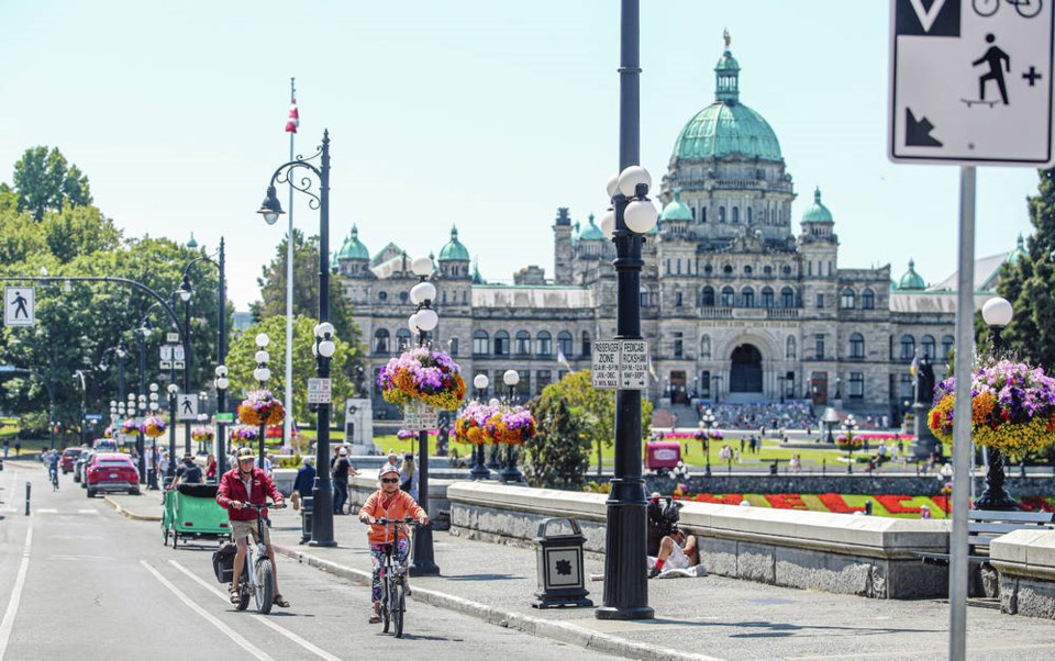
A report going to councillors Thursday recommends a cycling-route design for Government that includes protected bike lanes, painted bike lanes, advisory bike lanes — painted bike lanes on either side of a shared middle lane — and a neighbourhood bikeway where vehicles share the road with cyclists.
“The design that’s being put forward is really what could be described as sort of a compromised mishmash of things. And, you know, it’s not perfect by any means,” said Corey Burger, policy and infrastructure chair for Capital Bike.
While Burger said it’s great to see three bike routes in James Bay moving forward after years in the making, and he is generally supportive of the recommended designs, he has some concerns about the plans for Government Street, which include both permanent and interim measures that will create a connection between cycling routes on Humboldt Street and Dallas Road.
Burger said the removal of the diverter means traffic may not be reduced enough on the street to meet the threshold for all ages and abilities cycling routes.
While plans for the 600-block of Government Street between the Royal B.C. Museum and the legislature, where painted bike lanes are recommended, do not meet AAA design guidelines, they will improve safety in a stretch that does not currently have any bike infrastructure, staff say in a report going to councillors Thursday.
The painted bike lanes are an interim measure because significant changes are expected on the block in the coming years, as a result of planned improvements to the museum, the legislature frontage and underground projects.
Burger said interim measures are a great way to get something built while waiting for anticipated road changes, but they have the potential to become permanent. Council should set a timeline to implement a better, permanent solution to the 600-block of Government Street, preferably by 2025, he said.
Sarah Webb, the city’s manager of transportation planning and development, said staff have tried to find the best balance for all road users, and the diverter was removed from designs based on public input.
“In terms of a trade-off in priority, that’s something we heard clearly, was the importance of being able to get in and out in both directions on Government Street into the neighbourhood,” she said.
Webb said traffic volumes on Government Street naturally taper around Michigan Street, where protected bike lanes will transition to one block of advisory bike lanes and then to a shared-use neighbourhood bikeway on quieter blocks.
Webb said the city is committed to bringing a permanent all ages and abilities solution to the 600-block of Government Street, but the painted bike lanes are recommended for now, because “you don’t want to build something and then dig it up a few years later.”
Two north-south routes on Government Street and Montreal Street and an east-west route on Superior Street represent about 3.5 kilometres of a planned 32-kilometre all ages and abilities cycling network, which is intended to improve road safety and encourage sustainable transportation.
Superior Street was selected over Michigan Street as the east-west route after two phases of engagement with the public that showed a majority preferred Superior, with 63 per cent of nearly 1,200 people choosing that route, according to the staff report.
Marg Gardiner, president of the James Bay Neighbourhood Association, said the east-west route sparked the most debate at public meetings for residents, who were split between the two options.
Those who preferred Superior, a wider street, saw it as able to accommodate protected bike lanes and therefore improve safety, but others were concerned about losing on-street parking in a neighbourhood where it’s already scarce, Gardiner said. Some residents were opposed to the route running on Michigan Street, because the road is too narrow to support protected lanes, she said.
“The problem with bike lanes anywhere is that you make some people happy and not others, because no matter what happens, you shift. You either shift cyclists or you shift parking, and so you have pluses and minuses no matter where you put it,” she said.
The recommended design for Superior includes protected bike lanes from Government to Montreal Street, and advisory lanes for the final block of the street. The design retains 71 of 144 parking spaces and includes an improved pedestrian crossing at Oswego Street and a new pedestrian crossing at Montreal Street.
The design proposed for Montreal Street, which has a speed limit of 30 km/h and recently had speed humps installed, requires minimal changes to be included in the city’s all ages and abilities cycling network.
regan-elliott@timescolonist.com