Proposed improvements to Victoria’s bicycle infrastructure are raising concerns from both cycling advocates and motorists.
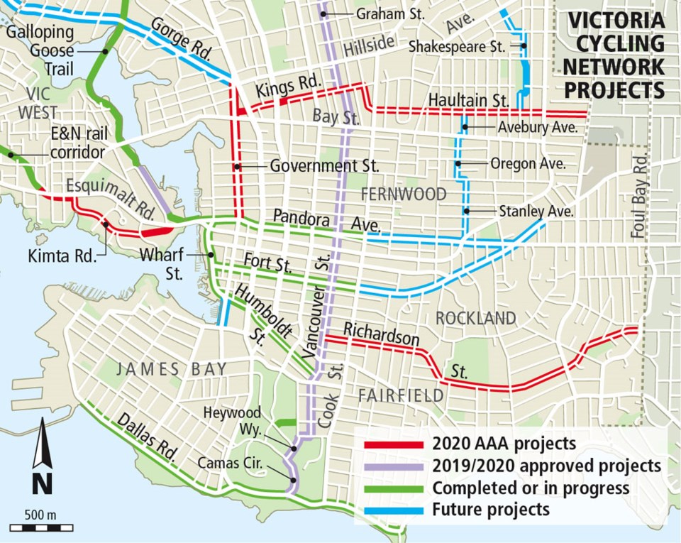
The city is holding open houses this week for residents to learn about proposed changes to Richardson Street, Government Street, Kimta Road and the Kings Road/Haultain Street corridor.
The city’s proposed changes for Richardson Street, which currently has no cycling infrastructure, include narrowing the space for cars to accommodate painted bike lanes on each side of the street.
Cars will still be able to travel in each direction, but will have to pull into the bike lane — yielding to cyclists — to pass oncoming vehicles.
The proposal put forward by the city indicates that Richardson Street currently accommodates about 3,500 to 4,000 cars per day. With traffic-calming measures, including prohibiting through traffic at some intersections, the city intends to bring the volume down to 3,000 daily cars or fewer.
Edward Pullman, president of the Greater Victoria Cycling Coalition, said that’s not nearly enough of a decrease in motor-traffic volume.
“The key with having these traffic-calmed streets is you need to reduce traffic speed and volume,” Pullman said. “We need more diversions that prevent through traffic, and a commitment from the city to reduce traffic volume to below 1,000.”
Sarah Webb, the city’s manager of transportation planning and development, said in an email that it would be too difficult to manage the spillover effects of reducing Richardson Street’s traffic volume to fewer than 1,000 vehicles daily, because there is no parallel route with the capacity to absorb that much traffic.
Lee Ferreira attended an open house at City Hall Tuesday evening and was surprised to find that the proposed changes will make it impossible to take Richardson as a direct route downtown from his home on a nearby residential street.
“For us driving downtown, Richardson is our route,” he said. “I can see the argument for slowing traffic down a bit, but I don’t see why they need to reduce the volumes. It’s just pushing the volumes onto other roads.”
Ferreira said the proposed changes mean he’ll likely have to take Fairfield Road to get downtown, but that means passing through two school zones instead of one, and more stoplights. He worries that will put more stress on other intersections.
Webb said the city is trying to balance neighbourhood traffic and on-street parking with pedestrian and cyclist safety, which council has made a major priority for staff.
The city is proposing turning Kings Road and Haultain Street into shared-use roads where bikes and cars use the same lanes. Calming measures such as traffic circles, curb extensions, speed humps and medians in intersections are suggested to bring vehicle-traffic volumes down to fewer than 1,000 cars per day from between 2,500 to 3,000 per day.
The changes include the addition of a pedestrian- and cyclist-controlled crossing on Kings Road at Blanshard Street, where there is currently a median.
Pullman said there aren’t enough traffic diversions suggested for this route to bring traffic volume down.
On Government Street from Pandora Avenue to Gorge Road, which already has painted bike lanes, the city is proposing a redesign of the road that would create protected bike lanes on the outer edge of the road, separated from traffic by on-street parking. The bike lanes would be wider than the existing lanes, which is made possible by reducing vehicle lanes from four to three, including a dedicated left-turn lane.
Pullman said he mostly supports the city’s design, but has some concerns about sightlines around intersections.
In Vic West, the city’s proposed design for Kimta Road would narrow the lanes for vehicle traffic to create a two-way protected bike lane and preserve on-street parking on both sides of the road. The city has long-term plans to create an off-street bike path that will connect to an existing multi-use pathway.
The city shared planning information with transportation staff in Saanich, Oak Bay and the Capital Regional District, and has already had significant public participation in online surveys, community meetings and walking tours, Webb said.
Residents are invited to learn more about the bike-network design and proposed road changes at open houses today from 4 to 7:30 p.m. at Bayview Presentation Centre, 80 Saghalie Rd., and on Saturday from 9 a.m. to 12:30 p.m. at Oaklands Community Centre, 2827 Belmont Ave.