Update: Rainfall warnings remained in place for much of Vancouver Island on Thursday morning as Environment Canada forecast continuing rain.
Environment Canada says between 20 and 30 mm of rain fell across the Greater Victoria region last night, with an additional 20 to 30 mm is expected for today. Localized flooding in low-lying areas is possible.
On inland and west Vancouver Island, a total of up to 100 mm is expected. Rain is expected taper to showers tonight.
Parts of East Vancouver Island are expected to receive more than 50 mm of rain by this afternoon. The area between Qualicum Beach and Fanny Bay is expected to receive even higher amounts approaching 100 mm.
A wind warning remains in effect for areas of east Vancouver Island from Courtenay to Campbell River and from Nanoose Bay to Fanny Bay.
Parks Canada has issued an extreme wave hazard advisory, notifying the public to use extra caution on beaches, shorelines and coastal waters in and around the park on Thursday and Friday. Very high wave conditions can create strong currents and shoreline flooding.
- - -
Original story
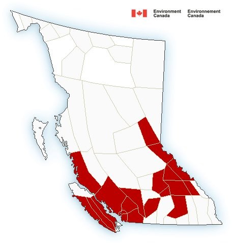
Environment Canada has issued a rainfall warning for most of Vancouver Island, including the Malahat Highway.
The weather service says a “vigorous” system is expected to stall across the island this afternoon and dump as much as 150 mm of rain in some areas by Thursday.
Carmen Hartt, a meteorologist with Environment Canada, warned people to watch for washouts and localized flooding.
“It’s more of a rainfall event than a wind event with this one,” she said.
The warnings apply to western, inland and eastern Vancouver Island, as well as the Malahat area of Greater Victoria, from Goldstream to Mill Bay.
Sutton Pass between Tofino and Port Alberni is getting some wet snow this morning. Freezing level will rise later today as the heavy rain arrives. #BCstorm #DriveBC #BChwy4 pic.twitter.com/GiCljz0D8R
— ECCC Weather British Columbia (@ECCCWeatherBC) January 2, 2019
Environment Canada said western Vancouver Island is expected to receive more than 150 mm of rain, while inland areas will get more than 100 mm.
The agency said parts of eastern Vancouver Island will receive more than 50 mm of precipitation, while the area from Qualicum Beach and Fanny Bay could receive up to 100 mm.
A wind warning is also in effect for areas of east Vancouver Island from Courtenay to Campbell River and from Nanoose Bay to Fanny Bay.
Weather warnings issued for heavy rain, heavy snow and very strong winds across #bc this morning for the upcoming #bcstorm. See link for more details https://t.co/9TjbLdh3Ha Tweet your rain/snow/wind reports with the hashtag #bcstorm.
— ECCC Weather British Columbia (@ECCCWeatherBC) January 2, 2019
Environment Canada said southeast winds will increase to 70 km/h and buffet exposed coastal sections of the island and the Sunshine Coast until midday Thursday.
The winds will be strong enough to damage roof shingles and windows, the agency said.
Buckle Up. #ShiftIntoWinter
— DriveBC VI (@DriveBC_VI) January 2, 2019
Snowfall, Wind, Rainfall & Winter Storm Alerts c/o @environmentca#BCHwy1 25-35 cm snow#BCHwy5 35 cm snow#BCHwy16 25 cm snow#BCHwy97 5-10 cm snow#BCHwy99 15-30 cm snow 50 mm rain#VanIsle 70-90 km/h wind#YVR #YXXhttps://t.co/eJ9Od6g1tf pic.twitter.com/LEzNbnMxgP
Environment Canada has posted snowfall, wind, winter storm and rainfall warnings for nearly two dozen regions across B.C., including Metro Vancouver and the Fraser Valley.
Snow is already falling in northeastern B.C., and the weather office says a further 10 centimetres of snow will fall in some areas, including the Peace River and Pine Pass on Highway 97. The system, and another packing 90 km/h winds on the central coast, is expected to ease by this afternoon.
The storm will then slide south prompting winter storm warnings for the Sea-to-Sky Highway and mountain passes on the Coquihalla, Trans-Canada and Yellowhead highways, with up to 35 centimetres possible on the Coquihalla by late Thursday.
— With a file from The Canadian Press