Flooding led to several road closures on Monday. See our updated story here.
Several sections of highways on the Island and Lower Mainland have been closed because of flooding and mudslides caused by heavy rainfall, and many rivers are running high and could overflow their banks.
Flood watch and high stream-flow advisories were issued Sunday afternoon by the B.C. River Forecast Centre for rivers on Vancouver Island and the Lower Mainland.
The rain is expected to be at its heaviest from Sunday afternoon into late morning Monday. When the rain eases, Environment Canada is forecasting winds to pick up. It has issued a wind warning for Greater Victoria advising of west winds of 30 km/h with gusts to 60 km/h. Exposed coastal areas could have gusts to 90 km/h.
A flood warning is in effect for the Coquihalla River. A flood watch is in effect for Central Vancouver Island’s Englishman River, where flows were high on Sunday afternoon, and are expected to go higher because of the rain. Flows could reach or exceed the flood stage in the Parksville area.
The river centre is warning people to stay away from waterways because of unstable banks and fast-moving water.
Snow melt caused by warm temperatures at higher altitudes joined the heavy rain in causing high and fast river flows.
Saanich police asked drivers to stay off the roads Sunday night because of the heavy rain. Large pools of water are forming on roads and motorists need to use extreme caution, said Const. Erin Heywood.
Police responded to numerous motor vehicle incidents related to the weather on Sunday afternoon and evening, Heywood said.
The Trans-Canada Highway northbound from the McKenzie interchange to Helmcken Road was closed for a time because of the weather.
The B.C. Transportation Ministry said Cowichan Bay Road had to be closed in both directions between Tzouhalem Road and the Trans Canada Highway due to flooding.
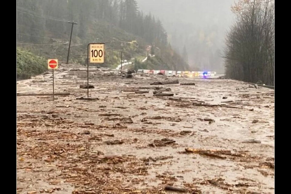
On the mainland, the ministry advised against travel on Highway 1 and the Coquihalla Highway in the Fraser Valley and Fraser Canyon because of flooding, mudslides and rock slides. Drive B.C. reported numerous highway closures, including the Coquihalla (Highway 5) from Hope to Merritt because of mudslides. Sections of Highway 1 were also closed.
Highway 7 (Lougheed Highway) was closed to all traffic at Ruby Creek west of Agassiz because of a mudslide. Reports on social media said debris struck some vehicles.
The City of Abbotsford opened a reception centre for residents displaced by flooding and mudslides. The city said heavy rainfall has resulted in small mudslides and localized flooding in many areas. No injuries have been reported. Several parts of the city have been closed to traffic.
In Victoria, the city is asking citizens to help keep sidewalks, gutters and drains clear of leaves to prevent clogging of drains; clogging could lead to flooding.
On Sunday morning, about 4,000 customers on southern Vancouver Island were without power because of downed wires, likely caused by wind and heavy rain. B.C. Hydro crews had dealt with most of the outages by the afternoon.
The bulk of nine outage areas, affecting about 3,000 customers, were in Highlands, Langford and View Royal. A smaller number of customers in Victoria, Saanich, and Colwood were also affected.
About 250 customers were without power in Nanaimo at noon and all but five were resolved by 3:30 p.m.
On the mainland, landslides knocked out power over an extensive area that included Hope, Spuzzum and Yale, B.C. Hydro said. Many customers are without power overnight. Repair crews are facing difficult weather conditions and the threat of additional landslides, but are working where it is considered safe to do so.
B.C. Hydro was also facing difficult conditions dealing with outages in the Golden, Parsons, Donald and Field areas where heavy snow has knocked trees onto power lines. Crews are working through the night.
— With files from the Vancouver Sun
- - -
A weather system bringing “copious amounts of rain” has hit southeast Vancouver Island and the Southern Gulf Islands, and is expected to continue until Monday. Temperatures are forecast to be unusually warm on Sunday, with a high of 15 C.
A rainfall warning, triggered by an “atmospheric river,” went into effect late Saturday afternoon, predicting up to 75 mm of rain. Heavy downpours could cause flash flooding and pooling of water on roads, Environment Canada said.
The rainfall warning includes Greater Victoria, Goldstream to Mill Bay, Duncan to Nanaimo, and Nanoose Bay to Fanny Bay.
Rainfall on the west coast is forecast to dump between 100 and 150 mm of rain by Monday morning. Port Renfrew can expect up to 150 mm while Tofino and Ucluelet could see up to 75 mm.
As the warm front approached Saturday, steady rain developed in the afternoon. The temperature is forecast to rise to 11 C on Sunday morning and hit 15 C by midday Sunday.
Environment Canada has forecast the rain will be heaviest Sunday afternoon into early Monday morning ahead of a cold front that is associated with this system. Temperatures are expected to dip to 6 to 8 C by mid week.
An alert is in place for the Malahat Highway from Goldstream to Mill Bay.
On the west coast, residents are warned river levels will rise and river flows will increase as a result of the heavy rain.
ceharnett@timescolonist.com