A storm that brought heavy rain and flooding on Monday led to multiple road closures — including the Malahat, the Trans-Canada Highway near Duncan and Highway 14 east of Sooke — and left thousands on the Island without power.
The Cowichan Valley Regional District declared a state of local emergency amid road closures and evacuations caused by record rain totals.
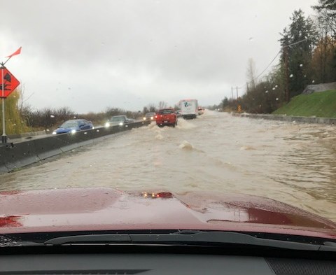
The Malahat was closed in both directions between West Shore Parkway and South Shawnigan Road, and Finlayson Arm Road was also closed at the lower end due to flooding.
Emcon Services, the highway-maintenance contractor for the south Island, said the highway was expected to remain closed in both directions overnight Monday, as the volume of water prevented a geotechnical assessment of whether the road was stable.
The Duncan-area highway closure was near Mount Sicker Road.
B.C. Ferries said it would run the ferry between Brentwood Bay and Mill Bay through the night after the road closure led to increased traffic on the route.
Janelle Staite, south coast region representative for the Ministry of Transportation, said Monday the rapid rise in water levels as a result of heavy rains was overwhelming culverts adjacent to roads, resulting in multiple closures of side roads.
“Our focus right now is safety, making sure people travelling on the roads are safe, as well as our contractors.”
Afternoon winds that followed the rain led to close to 48,000 power outages in the south Island by 4:30 p.m. The West Shore and Sooke had a combined total of about 30,000 outages during the afternoon.
The Cowichan Valley Regional District state of emergency declaration covered North Cowichan, Duncan, the Cowichan Tribes, the Halalt First Nation and the Penelakut Tribe. The regional district said residents in low-lying areas, especially those prone to flooding, should be prepared to evacuate at any time. It said door-to-door notifications will be given if needed.
An evacuation order was issued for Meadow Glen apartment building on Canada Avenue in Duncan on Monday morning, with displaced residents and others needing assistance sent to a reception centre established at the Cowichan Community Centre.
Lakes Road, between Beverly Street and Trunk Road, was closed to all traffic on Monday afternoon after crews deployed a gate to alleviate flooding in the area, as well as to the south end of North Cowichan and Duncan.
The Transportation Ministry said Cowichan Bay Road had to be closed in both directions between Tzouhalem Road and the Trans-Canada Highway due to flooding.
In Nanaimo, search-and-rescue boats were launched Monday to rescue any of the 13 residents remaining at a mobile-home park on Raines Road, as flood waters rose and high tides were expected at 2 p.m. Nanaimo Mayor Leonard Krog said the area borders the Nanaimo River and has had previous flooding problems.
Krog said about 280 millimetres of rain has fallen on the harbour city since the start of November.
In response, Nanaimo Public Works activated its departmental operations centre to direct resources to priority areas quickly, or support requests from other communities. “Nanaimo is fortunate to have avoided the misfortunes of communities outside our borders, such as within the Regional District of Nanaimo at the lower Nanaimo River, or North Cowichan near Chemainus,” Krog said in a statement.
He advised residents to take precautions, with the ground saturated and winds of up to 90 kilometres per hour in the forecast.
The Dashwood Fire Department tweeted that it was evacuating multiple campgrounds near Qualicum Beach, with residents directed to the Qualicum Beach Civic Centre, while Arrowsmith Search and Rescue helped evacuate a flooded mobile home park in Parksville.
Environment Canada meteorologist Armel Castellan said the past two months have seen about 200 per cent of normal precipitation for the province for this period.
“We were dealing with very wet conditions leading up to this potent and strong ‘atmospheric river’ that has tapped into subtropical moisture,” Castellan said.
“We’re seeing what has fallen in the last 24 or 36 hours as being equivalent to or surpassing some monthly November statistics for some locations.”
Wet weather since September has caused considerable saturation of the ground, which can lead to landslides, he said.
Flood watches were issued by the B.C. River Forecast Centre along rivers on Vancouver Island, including one for the Englishman River, while B.C. Hydro warned that extra water was being released down Elk Falls and the Campbell River through to Wednesday, telling anyone near the area to exercise extreme caution near “fast water flows.”
The rain is expected to be followed by “a very sharp cold front” featuring winds gusting from 70 to 90 kilometres per hour near the Salish Sea, which could lead to power outages, Castellan said.
Temperatures are expected to dip to 6 to 8 C by mid-week.
jbell@timescolonist.com


