New Zealand’s Whakaari/White Island erupted suddenly in December. Beneath the volcanic island’s crater, magma-heated seawater near-instantaneously evaporated, causing an explosion of steam, toxic gases, water, ash and rock that blasted 3,700 metres into the air.
Nineteen people have died as a result.
Last week, the Taal Volcano blasted steam, ash and pebbles 10 to 15 kilometres into the sky above Manila in the Philippines. Authorities urged 450,000 people living within 14 kilometres of the volcano to evacuate immediately.
On the opposite side of the Pacific Ocean, the Shishaldin Volcano in Alaska’s Aleutian Islands has spewed ash clouds 7,620 metres up and into flight paths in recent weeks.
The eruptions are unrelated.
British Columbia does not, at this time, have erupting volcanoes the way New Zealand, the Philippines and Alaska do, but we, too, are part of the Pacific Ring of Fire. This zone circles the Pacific region and is home to almost 90 per cent of the world’s earthquakes and 75 per cent of its active volcanoes.
The activity results from the various jigsaw pieces underlying the Pacific ocean and surrounding continental crust jostling and sliding against, over and under one another.
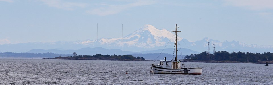
Although most of us are familiar with the iconic volcanoes of Washington, Oregon and California — Mount Baker, Mount St. Helens, Mount Rainier, Mount Hood — relatively few B.C. residents are aware that we have volcanoes, too.
Four of Canada’s five volcanic areas exist in B.C. Many B.C. mountains are, in fact, volcanoes, including mounts Nazko, Tseax, Hoodoo, Edziza, and — wouldn’t you know? — Volcano Mountain. Closer to home, here in southwestern B.C., mounts Garibaldi, Cayley, Meager and others keep volcano scientists interested.
The last big explosive eruption in B.C. happened 2,350 years ago, at Mount Meager, north of Whistler. Ash from the eruption spread as far as Jasper, Alberta. Researchers have also found pyroclastic flows — evidence of fast-moving rivers of super-hot, gas-charged lava and rock chunks the size of small cars — kilometres down the Lillooet Valley.
When the Tseax Cone erupted north of Terrace in 1775, an estimated 2,000 Nisga’a people died.
Canada’s most recent eruption occurred about 150 years ago, at the Lava Fork volcano in northwestern B.C. A 22-kilometre river of lava crossed into Alaska, damming the Blue River.
Since then, B.C.’s volcanoes have been quiet.
The biggest issue is that B.C.’s volcanoes are not well understood. No Canadian volcano is monitored thoroughly, systematically, or year round, and information is lacking.
Even if the likeliest threats were under constant surveillance, each volcano has its own unique personality. Knowing a few well wouldn’t help predict or understand the others’ behaviour.
Researchers south of the border, where volcano research is better funded and considered more of a priority, are seeking to understand the different personalities that make up the Cascade Volcanoes and the geology, physics and chemistry that underlie them. The Cascade Volcanoes run from Mount Baker to northern California.
For this reason, it’s fortunate that the biggest volcanic threat to the greatest number of B.C. residents is in Washington. Even though Mount Baker is only 25 kilometres from the Fraser River, its bulk lies south of the international boundary. Because of that, Mount Baker is well monitored, and B.C. municipalities and authorities are informed of changes in its activity.
If Mount Baker were to erupt, it’s believed lava flows would likely be a minor concern in B.C.
However, ash and landslides could be major problems.
Volcanic ash is angular and sharp and has been used as an industrial abrasive. It can destroy machinery and shut down jet engines. Depending on wind direction, ash from Mount Baker could cut off travel to the Lower Mainland.
Slides of cement-like mixtures of melted ice, snow, dirt and rock, called lahar, could sweep down Mount Baker’s north slopes and through Cultus Lake, Abbotsford and Chilliwack. They could block the highway and rail lines and dam the Fraser. When Mount St. Helens erupted in 1980, lahar buried forests, roads, creeks and rivers.
As to B.C.’s own volcanoes, the hazard map developed for Mount Meager by Simon Fraser University and Natural Resources Canada researchers in 2019 is the first hazard assessment for any Canadian volcano.
It shows that ash from a Mount Meager eruption could extend to Vancouver Island, Kamloops and beyond, depending on the wind.


