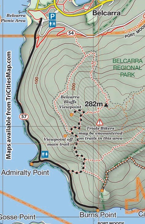
Hike Of The Week
Admiralty Point and Burns Point
Rating: easy
Time needed: 3 hours
Length: 5.5 km
Elevation gain: 230 m
This easy walk starts and finishes at the Belcarra picnic area and offers two nice viewpoints overlooking Burrard Inlet.
(Also described is an optional extension to the hike that climbs up to the Belcarra Bluffs Viewpoint. This adds another 2.6 km to the hike with an additional 300 m of climbing. The route to this viewpoint is difficult, and is only recommended for those who are proficient with a map and compass. Those skilled enough to find the viewpoint are rewarded with a spectacular vista and a great spot to enjoy lunch.)
From the Belcarra parking lot, head towards the left side of the concession stand and pick up the trail that runs parallel to the road. The trail will soon split; the upper trail (Springboard) heads towards Woodhaven Swamp, and the lower trail heads for Admiralty Point.
Continue on the well-signposted Admiralty Point Trail for another 1.5 km until you reach a fork in the trail near a pit toilet. Take the right path that heads down to the water.
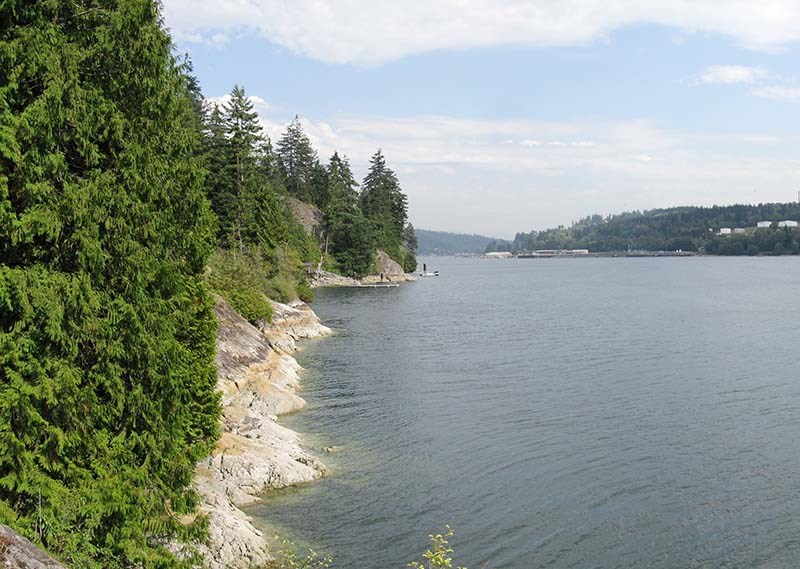
Admiralty Point is a rocky outcrop that juts out into Burrard Inlet, with pleasant views over the water that range from Burnaby Mountain to North Vancouver. There is also a plaque attached to the rock for those who want to learn a little more about the history of this area.
From Admiralty Point, retrace your steps back to the main trail and head right towards Burns Point, which is also well signposted. It’s about 1 km to Burns Point, with some uphill and downhill just before reaching the viewpoint. From here, you can see down Burrard Inlet towards Port Moody and also over to Burnaby Mountain and Barnet Marine Park. To return, retrace your steps.
THE TOUGH STUFF
For those wanting to find the Belcarra Bluffs Viewpoint, prepare for some tricky navigation:
At about the half-kilometre mark on the way back, look out for a faint trail heading off into the bush on your right. Ignore the first trail (it peters out) and take the second trail, which is about 20 m further on. The trail is difficult to follow but is flagged as it winds upwards through the bush.
At the site of an extensive area of deadfall the sketchy trail intersects a more prominent trail. Follow this to the left to another T-junction in about 200m. At the T-junction turn left again and follow the much wider trail upwards to yet another intersection. The trail heading right is less distinct than the main trail so be careful not to miss it. Follow the trail that branched right steeply upwards to another T-junction, where the way to the viewpoint is crudely signposted (left).
It’s about 300 m downhill before the trees open up into a big clearing with expansive views. Retrace your steps back to the parking lot. Although not far, this route is navigationally tricky, and is only recommended for those with map, compass and appropriate route finding skills.
Steve Chapman is a Coquitlam Search and Rescue volunteer, a member of the Burke Mountain Naturalists and the creator behind a detailed new map of Tri-City trails. More info on safe hiking: www.coquitlam-sar.bc.ca.