A team of scientists from Canada and Japan hoping to learn more about the underwater earthquake zone expected to cause the next “big one” departed on a research expedition from Sidney harbour Thursday.
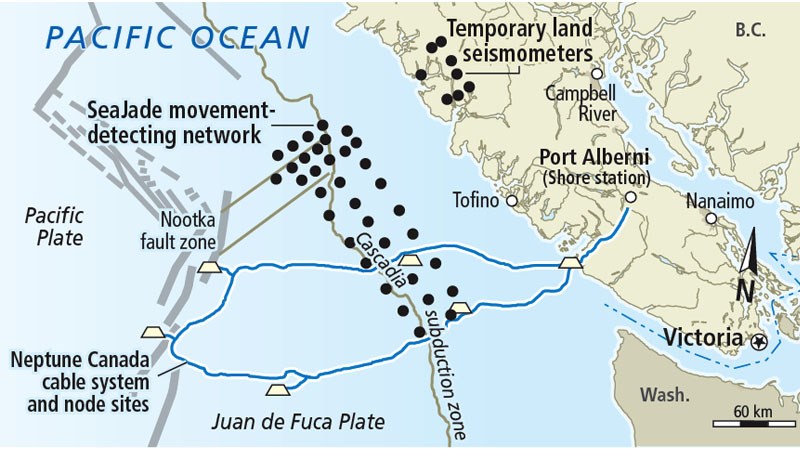
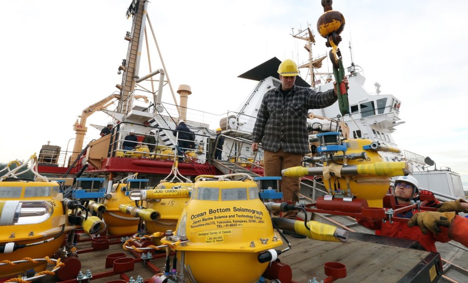
The team will spend 10 days placing instruments that detect movement along the northern Cascadia subduction zone, about 150 kilometres west of Tofino. The instruments, called seismometers, will collect data for 10 months.
The interface between the tectonic plates in the area is called a megathrust, said research scientist Kelin Wang. Megathrust earthquakes are large quakes characterized by the upward motion of one side of the fault.
“If it ruptures, [the impact] can be very, very large,” Wang said.
Since Canada primarily tracks earthquake activity through land-based readings, the project is expected to give scientists information that is much more accurate, said research scientist Garry Rogers.
“Small events that we might not see on land will be recorded well and we can locate events much better,” he said. “These instruments will be right on top of the earthquakes that are occurring.”
Knowing exactly where small earthquakes occur can also give scientists an idea of their cause. If there’s movement between two tectonic plates, for example, that would be one source, Rogers said. If it occurs within the Juan de Fuca plate, which is below the North American plate, then the movement is driven by stress.
The information will be used to develop better hazard models, he said, which could help plan for tsunamis, as well as develop better building and infrastructure construction codes.
A megathrust was responsible for the last massive earthquake on the West Coast in January 1700, Wang said. But because there were no advanced instruments at the time, scientists know very little about the conditions that caused it.
“Our problem is that our earthquake was 300 years ago and there were no instruments or recorded history of it,” Wang said. “But now we have instruments to detect crustal deformation.”
This is the second phase of the project, called SeaJade, he said. The first phase took place over three months in 2010.
During that phase, several movements were detected that didn’t appear on land-based monitors, Rogers said.
The followup was temporarily delayed when the Tohoku earthquake caused a devastating tsunami in Japan, Wang said.
The co-operative partnership involves Natural Resources Canada’s public safety geoscience program, the University of Victoria and the Japan Agency for Marine-Earth Science and Technology. The Japanese agency provided 35 ocean-bottom seismometers, while the Canadian team provided a research vessel.