A new E&N Rail terminal should be located on city green space being created through the elimination of the S-curve on the western approach to the new Johnson Street Bridge, says Victoria Coun. Ben Isitt.
“I think when we look at the economic vitality of the downtown, it’s important as the commercial and employment centre of Vancouver Island,” said Isitt, the Capital Regional District appointee to the Island Corridor Foundation, which owns the rail corridor.
“I think shortening the distance from the downtown to the rail terminus should be the top priority in site selection.”
The green space is one of three possible terminal sites identified in a staff report going to councillors on Thursday.
It is about a five-minute walk from downtown, compared to 15 to 25 minutes for the other two.
The three possible sites are:
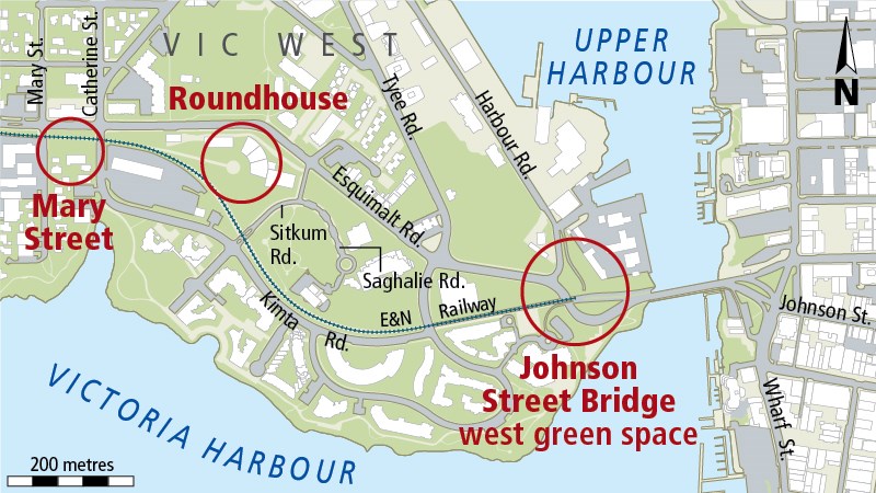
• Mary Street — A temporary site could be found on one of several smaller lots owned by the Island Corridor Foundation south of Esquimalt Road between Mary and Catherine streets.
Estimated walking time to the intersection of Johnson Street and Wharf Street, on the other side of the bridge, is 20 to 25 minutes.
• Roundhouse — Bounded by Esquimalt Road, Sitkum Road, Saghalie Road, Kimta Road and Catherine Street, the site is owned by Focus Equities.
Preliminary discussions with the owner suggest that if a station were to be located here, the owner would prefer it to be in the northwest corner.
There are existing connections to transit on Esquimalt Road. Estimated walking time to Johnson and Wharf streets is 15 to 20 minutes.
• Johnson Street Bridge west green space (site of the former S-curve) — The train could stop at the west side of the intersection of Esquimalt and Harbour roads, where the tracks currently end, or the tracks could be extended toward the harbour. Walking time to Johnson and Wharf streets is five to seven minutes.
The staff report says locating a terminal closer to downtown “strengthens the connection to the business centre and better services commuter and tourist-related passengers.”
Isitt noted that the city plans to open much of what is to be the new western approach to the new bridge on Wednesday. That will give motorists a first-hand look at the amount of surplus land that will be available once the new bridge opens.
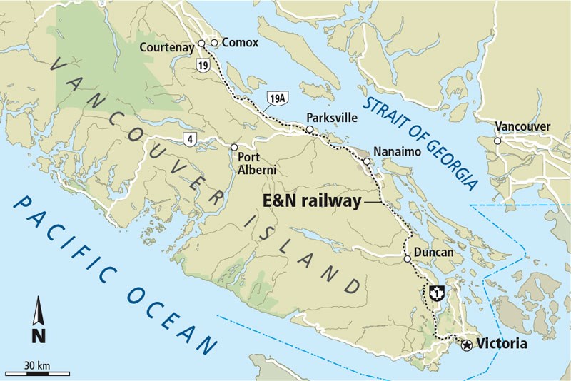
The railroad line runs from Victoria north to Courtenay. Passenger service was halted in 2011 because of concerns over the condition of the tracks.
Victoria city officials closed the Johnson Street Bridge to rail traffic in April 2011 after engineers discovered corrosion damage to key structural supports.
While a rail right of way has been preserved, a rail crossing was not included as part of the Johnson Street Bridge replacement as a cost-saving measure.
The former heritage-style terminal on the east side of the bridge was turned over to the Greater Victoria Harbour Authority, which has refurbished it. It is now a shelter for passengers awaiting cruise or whale-watching ships at Ogden Point.


