Saanich’s proposed Shelbourne Valley Action Plan is a 128-page blueprint meant to guide land use and urban design over the next 30 years.
The most urgent needs identified are enhancement of walking and bicycling to “create centres and villages that are exceptional places to live, work and play.”
Formally initiated in 2009-10, the plan has had several phases of public input.
These include community mapping completed by more than 1,300 people, nearly 1,500 responses to three community surveys, 33 meetings with the Shelbourne Valley Stakeholders Committee, nine open houses attended by 1,800 people, three flyer mail-outs to 11,000 businesses and residents in the area and 23 presentations to focus and community groups.
The draft plan presented to the public in November 2013 included a public survey completed by 359 people.
Since then, there has been no formal public consultation, but it’s coming.
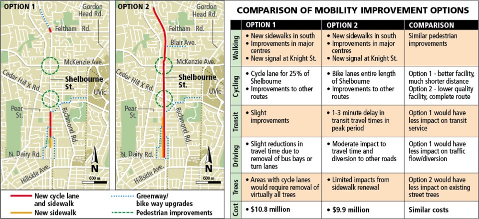
Rather than choose one of two major options for the four-kilometre Shelbourne corridor between North Dairy and Feltham roads, Saanich council unanimously voted this week to seek public feedback on both options.
Option 1, which could be implemented in the next seven years, includes some new sidewalks, a bicycle lane physically separated from motor vehicles for 25 per cent of Shelbourne Street, from Knight Avenue to Pear Street as well as from Torquay Drive to Feltham Road.
More than 300 trees, the vast majority of them healthy, would come down for the changes. Upgrades would be made to bike connector routes at the University of Victoria, Blair, Bowker Creek and Kingsley.
The four lanes of traffic would remain undivided general-purpose lanes, but some turn lanes and bus bays would be lost to sidewalk improvements.
Option 2 — with a timeline until 2038 — includes a bike lane for the entire four kilometres but reduces motor-vehicle lanes to two, three or four lanes in different segments in order to give cyclists a dedicated 15 per cent of the road. That would reduce vehicle and bus traffic share to 50 per cent.
Bus trip travel times could increase by one to three minutes in peak periods in what is identified as a frequent transit route by B.C. Transit.
At large key intersections, some utility poles would have to be moved.
Saanich would have to acquire easements and use parts of them to widen the road as properties change hands.
A study by Urban Systems for Saanich council noted that existing traffic volumes reach 1,000 to 1,200 vehicles per hour in peak periods.
If a travel lane is reduced between Feltham and North Dairy, as much as 15 per cent more peak period traffic will go to Cedar Hill Road, seven per cent more on Richmond Road and up to 20 per cent more to Gordon Head Road.
In the long-term vision, Shelbourne’s current right of way — from property line to property line — would increase from 20 to 23 metres to 28 to 30 metres, affecting “almost every property fronting Shelbourne Street,” the Urban Spaces report said.
It would provide four travel lanes, including two for rapid transit and two for private vehicles, the curb and gutter, a utility strip for hydro and street lights, and the cycle track bounded on the other side by boulevard with trees and sidewalk.