The District of Saanich is using a map app to track cycling crash hot spots as it moves ahead on cycling infrastructure projects and aims to improve its long-term transportation plan.
The municipality has released a cycling incident map based on BikeMaps.org data, Saanich police reports and ICBC records — information it is using to make decisions about what projects to undertake.
“It does allow cities to be more proactive in how we look at problem areas,” said Harley Machielse, Saanich’s director of engineering. “Instead of being reactionary, which is a traditional method in looking at ICBC crash data, this type of information allows us to be on the proactive side.”
BikeMaps.org is a crowdsourcing tool that allows cyclists to track near-misses, bicycle thefts, collisions, construction activity, potholes and other potential hazards. It was developed by a group of researchers in the University of Victoria’s Spatial Pattern Analysis & Research Lab.
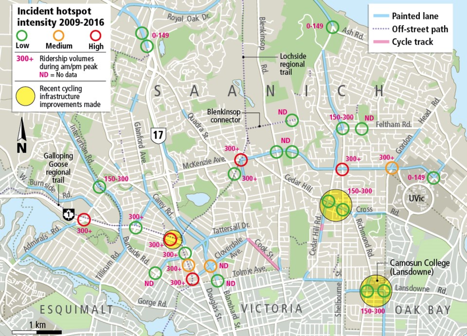
The BikeMaps.org team analyzed the Saanich data and created a map showing “hot spots” for incidents and near-misses, such as areas where the Galloping Goose Regional Trail intersects with motor vehicle traffic and at the busy Shelbourne and McKenzie intersection.
Project planners at Saanich used the results as criteria when selecting cycling infrastructure projects, including significant changes to three of the identified areas:
• Cedar Hill Cross Road — improvements to bike lanes
• McKenzie Avenue at Borden Street — ongoing construction of a separated cycle track connecting Lochside Trail across McKenzie
• Lansdowne Road — development of a multi-use path in front of Camosun College
Corey Burger of the Greater Victoria Cycling Coalition said Saanich’s map shows “many of the challenge points that our members tell us about.”
Karen Laberee, the research group’s executive director, said only 30 to 40 per cent of cycling crashes result in insurance claims or reports to police, and it often takes years for that data to be compiled and released publicly.
The app allows cyclists and city planners to track problem areas in real time.
Armed with massive amounts of data, BikeMaps.org has been trying to build partnerships with municipalities and is helping seven Canadian cities with their cycling transportation plans.
“We’ve got a lot of people taking time to put their reports on BikeMaps.org, so it’s great to see a municipality being proactive and using the data to help inform their planning,” Laberee said.
Saanich’s partnership with BikeMaps.org is part of its 25-year active transportation plan, dubbed Saanich Moving Forward, Machielse said.
In December, Saanich council voted in favour of a $12.5-million plan that would improve pedestrian walkways and add separated cycle lanes on both sides of Shelbourne Street between North Dairy Road and Torquay Drive.
Vehicle traffic will be restricted to two lanes, down from four, between Broadmead and Kisber avenues and Garnet Road, and some drivers have expressed concern that the changes could clog traffic on an already busy artery.
The municipality is collecting public feedback through surveys and public meetings.
Machielse said improvements for pedestrians, cyclists, transit riders and those with accessibility challenges will not come at the expense of drivers.
“It’s a concern that’s out there and how we install cycling infrastructure so it doesn’t create a situation where it’s in dire conflict with people who are commuting and driving,” Machielse said. “So we want to be conscious of that and how the cycling infrastructure is put in place so we’re balancing all modes of transportation.”


