At least 21 more parking stalls in the heart of downtown could be lost as Victoria builds the next phase of its protected all-ages-and-abilities cycling network.
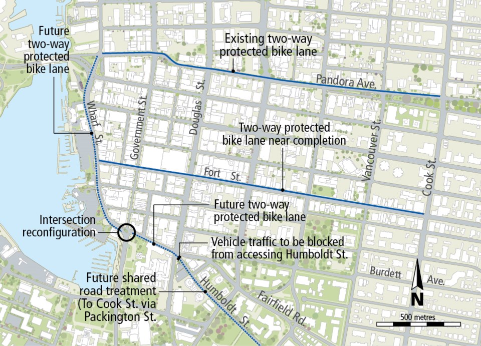
City staff estimate 21 of 45 on-street stalls on Wharf Street between Pandora Avenue and the Government/Humboldt intersection (but primarily in the 1200 block) will have to be eliminated to make way for a two-way protected bike lane on the west side of Wharf.
While less severe than some earlier estimates, director of engineering Fraser Work called the loss of the 21 stalls a “very significant loss.”
“But it really is the only place you can shave when you have that limited, constrained right of way. So, obviously, you can’t move out over that retaining wall. If you want to increase or enhance and continue to improve that pedestrian realm, you don’t want to skinny up the sidewalks. And you want to really make sure that the vehicle traffic can move through there,” Work said.
The design, currently 60 per cent completed, calls for the southbound left-turn lane at Fort Street to remain to allow for safe transit and commercial vehicle access and to allow cyclists to access the new Fort Street protected bike lanes.
There would be a major reconfiguration of the Wharf/Government/Humboldt intersection transforming it into a traditional, right-angle junction, instead of the existing curve junction. The new bike lane would end just south of the intersection.
Mayor Lisa Helps said the long-term thinking is that eventually the new bike infrastructure will attract more cyclists who aren’t on their bikes downtown now because they don’t feel safe. “They start leaving their cars at home and that frees up parking for other people who don’t want to or can’t bike,” Helps said.
“So in the short term, yes, there is concern about losing parking spots to put in bike lanes. In the long term, the system will sort itself out and there will be an equlibrium where there’s enough parking for people who need parking,” Helps said.
A Humboldt leg of the bike route is envisioned to eventually link to Cook Street. The next phase would see a two-direction separated bike lane built on the south side of Humboldt between Government and Douglas streets.
While the all-ages-and-abilities bike route will continue down Humboldt east of Douglas, it won’t be as a separated corridor.
Instead, the plan is to block off Humboldt at Douglas to motor traffic — essentially turning it into a cul-de-sac — and use “a shared road treatment” on Humbodlt between Douglas and Vancouver streets and on Pakington Street between Vancouver and Cook streets.
The closure will create the opportunity to create a new plaza near Douglas that could be traversed by cyclists.
The shared-road treatment would use a combination of paint markings, traffic calming and traffic diversion to make cycling safer. Key to a shared road being considered as part of a cycling network is reducing motor traffic volume and speed, Work said.
“We want to get those volumes down to around 1,000 vehicles per day. Then we can look at the speeds to make sure those speeds are down within reason. Then that can be considered a safe and comfortable facility for some of the less confident riders,” Work said.
Motorists wanting to travel east into Fairfield/Gonzales will use Burdett/Fairfield.
City staff are recommending the city move to detailed design and tender both the Wharf and Humboldt stretches of the network. They are recommending council fast-track the cycling network project proposed for Vancouver Street.
A similar shared-road treatment is planned for much of Vancouver Street, which city staff are proposing as an alternative to Cook Street for a north/south leg of the network.
While protected bike lanes are recommended to run on either side of Vancouver between Pandora Avenue and Fort Street, a “shared road” approach is planned on Vancouver south of Fort and north of Caledonia.
City staff say that while some parking would be lost on Vancouver between Fort and Pandora, overall an additional 35 stalls could be added south of Meares.
No cost estimates are included in the report.
Work said costs for routing along Vancouver using a shared-street approach will undoubtedly be less than building separated bike lanes on Cook.