From high above two pods of orcas near Telegraph Cove, a drone captured images that hold clues to the threatened species’ health.
Northern resident killer whales are picky eaters, with an almost exclusive diet of chinook salmon. Using aerial images such as those taken on Thursday, researchers are keeping track of the whales’ size in relation to salmon abundance over time — from a perspective they can’t get on a boat.
“We caught them when the water was flat, so we’ll get good-quality images today,” said Lance Barrett-Lennard, senior marine-mammal scientist with the Vancouver Aquarium, who is working with the National Oceanic and Atmospheric Administration in the U.S.
Unmanned aerial vehicles, commonly known as drones, pose risks to both humans and animals when used irresponsibly. Washington state Fish and Wildlife officers ticketed two drone operators for flying too close to whales near the San Juan Islands last year. And firefighting efforts had to be halted twice last year and once this year, when amateurs flew drones over B.C. wildfires.
But increasingly, everyone from researchers to firefighters are finding ways to take advantage of the new technology.
For Barrett-Lennard, that means flying a quiet device at least 45 metres high, which he says has no impact on whale behaviour.
“I’m obviously a proponent of drone use for the kind of study we’re doing, but you have to be careful with them,” he said.
Researchers with the Center for Whale Research began taking aerial footage by helicopter in 2008 and 2013. But drones offer a much cheaper alternative to the $1,000 US per day for hiring a helicopter, research director Deborah Giles said.
The centre will soon go a step further and start collecting video footage, for a study of social dynamics between southern resident killer whales.
It contracts commercial operators with permits and pilot’s licences to ensure the drones are flown safely and unobtrusively, Giles said.
Others are also using the new technology.
The B.C. Wildfire Service is officially using drones to map fires and identify hot spots, after two years of test runs — also contracting commercial operators.
“We’ve had drones out on the fire line for a total 35 days so far this season,” said provincial fire information officer Erin Catherall.
They were used extensively in May near Fort St. John, she said, and during at least one fire on Vancouver Island.
Since they’re unmanned, they’re much safer than collecting images via low-flying helicopter, she said.
During the day, drones help map fire perimeters, terrain and burn patterns. And unlike helicopters, they can fly at night. That means identifying hot spots sooner, so crews can attack them first thing in the morning.
“With drones, we’re able to be a few hours ahead,” Catherall said.
But hobby drones have also damaged firefighting efforts. RCMP investigated two incidents of amateurs flying drones close to wildfires in 2015 near Kelowna and Oliver, and one this year near Fort St. John, she said.
“This is incredibly dangerous to our fire-line crews, as well as our air crews,” Catherall said. “If a drone made contact with a helicopter, it could cause a severe accident.”
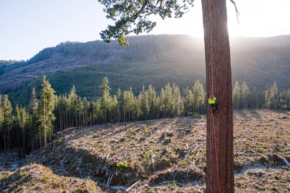
The Ancient Forest Alliance is using drones to draw public attention to its campaigns. It released a video Thursday showing a climber scaling Big Lonely Doug, Canada’s second-largest Douglas fir, which stands in a clear-cut near Port Renfrew.
Videographer and photographer TJ Watt said drones help capture pictures of environmental destruction that would not be possible otherwise.
“It gives us unparalleled access to areas that were hard to reach before, such as clear-cuts past rugged terrain,” he said.
“Drones allow you to bring video and photos of these remote areas into people’s living rooms.”
In his 10 years working with the environmental group, he said, technology has changed the way people interact with photography and videography significantly.
“People’s attention spans are fairly short these days, so in the age of viral videos and 30-second video clips, we need to come out with captivating and interesting visual material,” Watt said.
“Drones and high-end technology really allows you to bring these remote and endangered areas to life.”