The first of three successive storms due to hit Greater Victoria caused only about 2,500 residential power outages Wednesday night and early this morning, with that number down to just two outages around 10 a.m.
After a reprieve from rough weather during the day, the second in the series of storms is expected to arrive in the late afternoon.
The most powerful storm of the bunch could be the Saturday storm, which will come out of the remnants of Typhoon Songda from Asia.
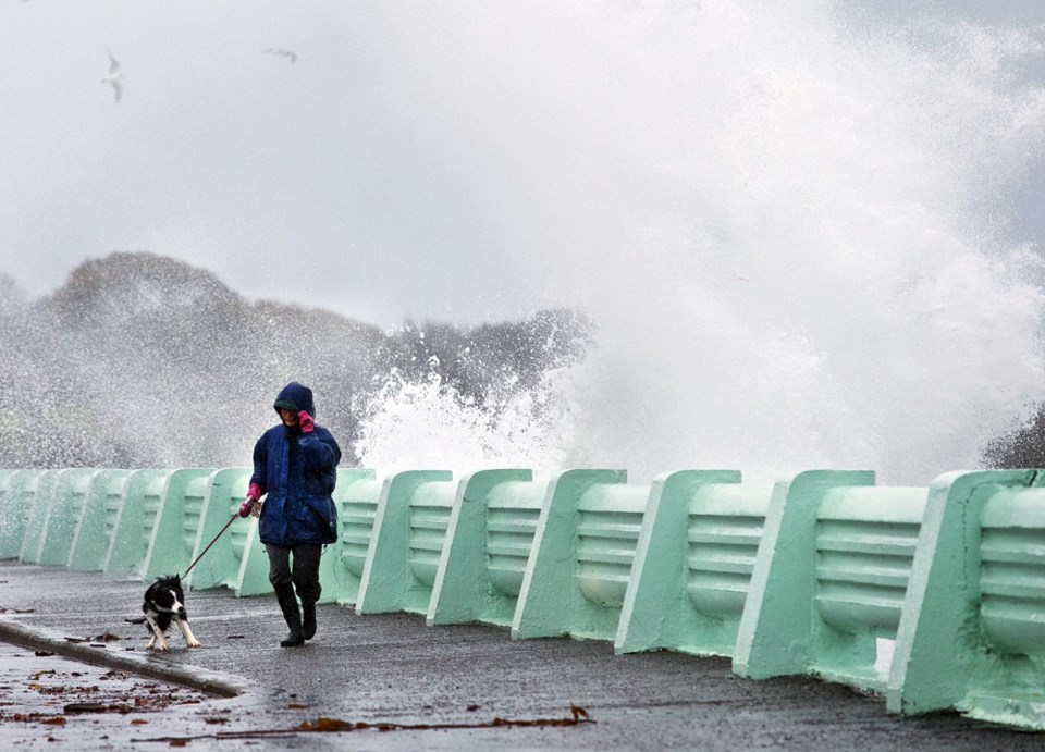
Environment Canada meteorologist Armel Castellan said the impact of that storm could be “historic” and that the overall rainfall total from the three storms could exceed 400 millimetres in some places, such as the west coast of Vancouver Island.
In Greater Victoria, heavy rainfall and winds up to 80 kilometres an hour are predicted.
Fraser Work, the City of Victoria’s director of engineering, said storm preparation has been underway for some time.
“A lot of our operations and maintenance leads us up to the fall program, so we want to have as much of our inspections of the underground utilities done as possible,” he said.
“We want to make sure that any blockages are cleared. We want to make sure that any actual physical upgrades or any changes to the underground infrastructure has been done.”
Every year, fallen leaves are a big factor in flooding.
“A lot of the success or fail of the infrastructure depends on how many leaves are either covering over or down into the storm drain,” Work said.
That is why the public is asked to help with keeping leaves away from problem areas, he said.
“We can’t get to all 6,000 or so catch basins.”
Watching the weather forecast is part of the process, Work said, and low-lying areas that could be susceptible to flooding are prioritized.
The tight grouping for this week’s storms is an issue, he said. “Coming in such short order, we’ll only be able to do so much.”
Anyone seeing water pooling on Victoria streets during heavy rain is asked to call 250-361-0400.
Victoria and other municipalities are advising the public to stock up on emergency supplies such as food, water, flashlights and batteries. In Sooke, residents can visit the public works yard, 2060 Kaltasin Rd., to fill their own sandbags as a precaution against flooding.
Sand and bags are being provided but people must bring their own shovels.
At B.C. Ferries, the first storm is expected to have come and gone before any sailings are affected, said spokeswoman Deborah Marshall. She said careful observation of the weather is vital, including conference calls with Environment Canada.
“We will give customers heads up if we think it’s going to affect ferry service,” she said. “We will be posting service notices if there are any warnings or advisories to give customers about cancellations or anything.”
The storm activity is expected to cause extreme waves and ocean swells up to nine metres in Tofino, prompting Parks Canada to issue a hazard advisory for Pacific Rim National Park. The public is warned to use extra caution on beaches, shorelines and coastal waters through Monday.
Very high tides are expected around midday each day, which could flood beaches, send large waves high onto the shore and create extremely hazardous surf conditions.
Certain beaches and beach parking lots in the national park could be closed depending on the severity of the flooding seas, said Parks Canada spokeswoman Crystal Bolduc. Signs will advise of temporary closures.
Visitors who want to storm watch can do so from safe locations such as Kwisitis Visitor Centre Observation Deck at Wickaninnish Beach, Florencia Bay lookout, and Tonquin Trail viewpoints, all in Tofino, or Amphitrite Point in Ucluelet.
jwbell@timescolonist.com
— With files from Katie DeRosa
- - -
Earlier story:
Be prepared for not one but three powerful storms the rest of the week, beginning with rain and wind hitting the region late Wednesday.
A special weather statement to warn people in Greater Victoria has been issued about the three events, with the second slated for Thursday afternoon and the third for Saturday, said Environment Canada meteorologist Armel Castellan.
As details become available, warnings will be issued through the week at weather.gc.ca/warnings.
The storms will affect much of the B.C. coast and could bring overall rainfall totals of 400 millimetres or more for parts of western Vancouver Island and other sites, although the Victoria area rain total will be lower and possibly approach 50 mm by Friday, Castellan said.
Winds could exceed 80 kilometres per hour in many areas, including Victoria.
Castellan said the first storm will peter out over the course of Thursday morning before the second in the three-storm sequence kicks in after “a little bit of respite.” The second storm will stay around into Friday before another break from storm activity, then more rain and wind will emerge from the remnants of Typhoon Songda. The typhoon has been active along the coast of Asia and will be making its way to North America.
“It will be a Saturday-into-Sunday event,” Castellan said. “It remains a very big enigma in terms of how bad or how it’s going to manifest itself.”
Such “post-typhoon-like” storms are hard to predict, he said, but the one coming here could be “historic” in its cumulative effects and total rainfall.
As always, B.C. Hydro is aware of the looming conditions and is prepared to deal with concerns as they arise, said spokesman Ted Olynyk.
The corporation has its own meteorologist, he said. “We monitor the weather quite closely for our grid and for our generation facilities.”
Different steps can be taken prior to a weather system arriving, Olynyk said.
“Do we pre-deploy? When and where do we send staff home early, so that way they can be on rest time and be available to deal with the storm when it comes in.”
Castellan said the coming storms could damage trees, as was the case in the storm that hit Greater Victoria last week. He said the large amount of leaves still on many trees can catch the wind and increase potential problems.
“The leaves act like a sail in the trees, so a lesser wind can take a tree down.”
With the trio of storms approaching, the B.C. River Forecast Centre is monitoring the Courtenay and Port Alberni regions for flooding issues, Castellan said.
“That’s where the rivers have potential to crest.”
Rain could dominate the weather for much of next week, he said.