As a kid growing up in Victoria, I loved to cajole mom or dad into making a detour on the way home and driving up Mount Tolmie.
Looking down over an expanse of houses, cars and roads rendered miniature by distance was something I never got tired of.
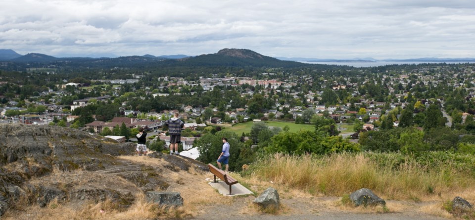
Today, the lookout area is as popular as ever. Locals stop by, as do buses laden with tourists.
“It’s one of the best views in the city, really,” said Dave Lock, president of the Mount Tolmie Conservancy Association. “You get a 360-degree view, water view all the way around, pretty much.”
>> FIND MORE THINGS WE LOVE HERE
Straight ahead from the summit is the Shelbourne/Cedar Hill neighbourhood; to the right and behind are Gordon Head and the University of Victoria. Downtown Victoria, Beacon Hill Park and Strait of Juan de Fuca are to the left.
The Mount Tolmie Conservancy Association, active for the past 19 years, has made a huge impact on the area, with members volunteering their time to remove invasive plant species and generally act as stewards of the land. The group has also overseen the planting of Garry oak seedlings and several varieties of shrubs, and was presented with an Environmental Achievement Award by the District of Saanich in 2008.
Late Victoria Times columnist Arthur Mayse described Mount Tolmie many years ago in less-than-majestic terms, calling it a “rocky 407.5-foot nubbin.” It may well be more hill than mountain, but it still poses a challenge to the steady stream of runners venturing to its 124-metre peak, and was the centrepiece of cycling road races during the 1994 Commonwealth Games.
The name Mount Tolmie, after Hudson’s Bay Co. surgeon Dr. William Fraser Tolmie, began to come into common use in the mid-1800s. Park status started to emerge in 1891.
Here’s a surprise for most: Also in the 1890s, real estate developer J.H. Brownlee built a roller-coaster atop the local landmark. But it didn’t last long — the wooden structure was destroyed by a brush fire in 1896.
The summit was also the site of a coastal-defence building during the Second World War. It provided a VHF link to Vancouver and Island areas north of Duncan.
The concrete slab at the top of Mount Tolmie today is likely the structure’s base.
A reservoir was added in the 1960s, and in recent years, its flat, grass-covered surface has provided a concert venue for musical group Raven Baroque.
For walkers and nature lovers, Mount Tolmie’s 20 hectares of parkland boast more than 1,500 metres of trails, along with picnic areas and plenty of prime spots to play or commune or perhaps watch some of the estimated 100 species of birds that favour the slopes.
Thank the conservancy association for making the natural setting all it can be.
“We focus mainly on pulling broom,” said Lock. “Broom isn’t the only thing up there, though. Ivy is a terrible problem, and there’s daphne and Himalayan blackberry.”
Many types of wildflowers have had a resurgence with the removal of broom, he said. “In the open meadows areas, it’s quite extraordinary, the camus in particular.”
School groups are regular contributors to work parties that Lock organizes to keep unwanted plants at bay. Lock said that St. Michaels University School, which is located nearby, has made a great contribution, as has Oak Bay Secondary, where he used to teach and run an environment club.
“We’ve also had the Island Montessori group coming and we’ve had Scout groups, as well.”
Road access to Mount Tolmie is via Mayfair Drive, which extends to the summit from either Richmond Road or Cedar Hill Cross Road.