In the early 1840s, the rising flood of American settlers into the area of Fort Vancouver worried the governor of the Hudson’s Bay Company. In A Perfect Eden, local author Michael Layland describes how George Simpson gave orders that James Douglas go to the southern end of Vancouver Island to reconnoiter a new base for HBC’s West Coast operations.
Later called the Father of British Columbia, James Douglas was born in British Guiana, the son of a Scottish plantation owner and a woman from Barbados, probably herself of mixed race. Douglas had joined the Hudson’s Bay Co. at 15 years of age. Fluent in English, French and Chinook jargon, he had already acquired a wide range of practical, operational and leadership experience in the northern fur trade. Douglas cut an imposing figure, as described in Simpson’s confidential appraisal, written in the early 1830s:
“A stout powerful active man of good conduct and respectable abilities … has every reason to look forward to early promotion and is a likely man to fill a place at the council board in course of time.”
With his own background, and the reliable force that was his vessel Cadboro, and its crew to support him, Douglas had few qualms about taking just a handful of men to explore inland, notwithstanding Simpson’s warnings about the ferocity of the people he might meet there. The six-man exploration team he assembled included two millwrights, reflecting the importance that a water-powered mill would have for a new, major establishment. Needed for both grinding grain and sawing lumber, the mill could be on a freshwater stream or at a location to exploit tidal power.
He also included a draftsman-clerk, Adolphus Lee Lewes — the son of a fellow chief factor — who had recently returned from “a regular apprenticeship in [England] in the land surveying business ... and in nautical surveying.”
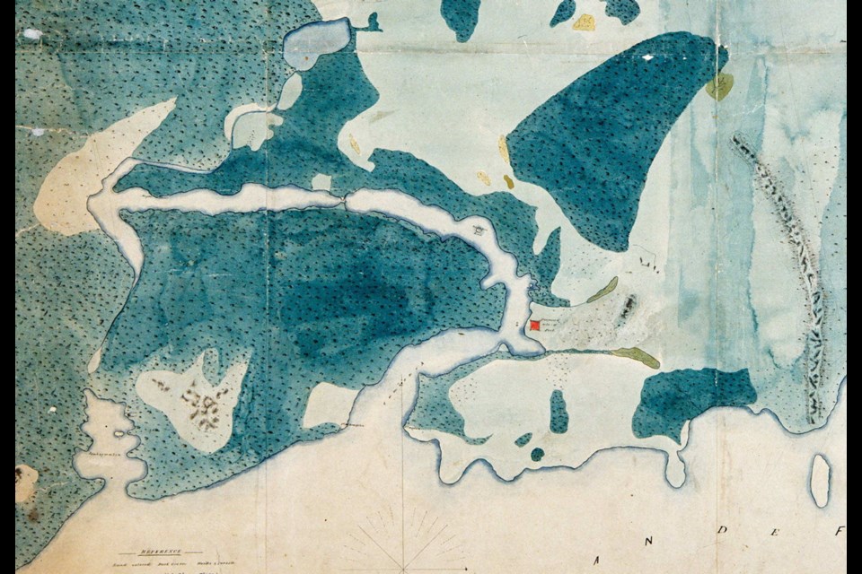
Lewes and Douglas surveyed the area surrounding the selected site, and their map, called a ground plan, accompanied Douglas’s subsequent report. They had brought two horses, and it is evident from the extent and detail shown on the map that the pair was able to cover considerable ground during their few weeks on site, and that they employed the services of local guides.
It is not clear in which order Douglas inspected “several forts and harbours” along the coast between Point Gonzalo (Ten Mile Point, not today’s Gonzales Point) and Sy-yousung (Sooke), nor where he landed. It would seem that he coasted beyond Sooke.
“[T]he south west point of the Island [perhaps San Juan Point] opposite Cape Flattery, and running westward from it ... there are no safe harbours for shipping and the country is high, rocky and covered in woods, presenting in its outline the almost unvarying characters of the coast of North west America, to which unfortunately it bears a too faithful resemblance.”
However, the shore to the east was more promising.
“[The coast] from Port Sy-yousung to Point Gonzalo, is less elevated, more even and diversified by wood and plain; the coast is indented with bays and inlets; there are several good harbours, with anchorage at almost every point where vessels may bring up in calms.”
Douglas’s report described the positive and negative aspects of each of the five harbours he considered: Sy-yousung (Sooke), Whoyung (Becher Bay), Metcho-sin, Is-whoy-malth (Esquimalt), and Camosack (Victoria). As well as a good, all-weather harbour suitable for ocean-going shipping, he was seeking a reliable source of fresh water, and a “tract of clear land sufficiently extensive for the tillage and pasture of a large agricultural establishment.”
This last requirement effectively ruled out all of them except Camosack, even though the harbour itself was not as good as its neighbouring Is-whoy-malth: “one of the best harbours of the coast, being perfectly safe and of easy access.” On balance, Douglas decided in favour of:
“[T]he decided superiority of Camosack over the other parts of the Island, or of the continental shore known to us, as a place of settlement. The situation is not faultless or so completely suited to our purposes as it might be, but I despair of any better being found on this coast, as I am confident that there is no other sea port north of the Columbia where so many advantages will be found combined.”
From the amount of cartographic detail depicted on the ground plan, it is clear that the major part of the expedition’s effort must have been devoted to the area surrounding the Canal of Camosack, known today as the Gorge, and the quantity of text in the report confirms this. The banks of the harbour and the “canal” were mapped very carefully, and particular attention was paid to sources of fresh water. Areas of plains or prairie, woods and rock outcrops were differentiated.
A dotted line indicates that Douglas — probably accompanied by Lewes and a guide — followed a trail departing from the proposed site of the new fort, curving east then northward, crossing a line of rocky hills (about today’s Oak Bay Corners), and then on to a place intriguingly marked “Battle Field,” (about today’s commercial centre of Oak Bay).
No evidence or reports have surfaced of any battle ever having taken place there, and it seems probable that this was a linguistic misunderstanding. At best, Douglas would have been trying to converse with the Lekwungen guide in the very limited vocabulary of Chinook jargon.
One possibility is that the name derived from a nearby village at today’s Gonzales Point, Kukleeluk, which roughly means “place of conflicting waters,” referring to the fierce tidal rips between the point and Trial Island.
Douglas noted in his report that the tract of clear land crossed by the trail he had taken (today’s Fort Street and Cadboro Bay Road) and running inland for some six miles, was “the most picturesque and decidedly the most valuable part of the Island that we had the good fortune to discover.”
Lewes drew the coastline of Cadboro Bay quite well, indicating an “Indian Fort” at the northern end by some representative houses. The only other signs of Indigenous habitation on the map are a similar “Indian Fort” at the head of Is-whoy-malth, and a few patches of cultivation — probably camas — along the Gorge, around Beacon Hill, and near McLoughlin Point.
Subsequent archeology confirms the impression gained by the boat parties of the Eliza expedition a half-century earlier, that many villages populated the coastline, so their omission on Lewes’s map is a mystery. The houses at Cadboro Bay are now known to have been Sungayka, the fortified, principal village of the Chekonein people, also called Samas or Samose, which became Songhees.
The team discovered no freshwater stream in the vicinity of the site selected for the fort with sufficient flow for a water mill; however, the two millwrights in the party examined the narrowest part of the Gorge, and advised that constructing a wheel to generate power from the tidal flows would be feasible “at a moderate expense.”
Douglas, despite the circumspect wording of his recommendation for the Port of Camosack as the site for the new establishment, was most impressed with the delightful location. As he wrote in a well-known letter to a friend:
“The place itself appears a perfect ‘Eden,’ in the midst of the dreary wilderness of the North west coast, and so different is its general aspect, from the wooded, rugged regions around, that one might be pardoned for supposing it had dropped from the clouds into its present position … The growth of indigenous vegetation is more luxuriant, than in any other place, I have seen in America, indicating a rich, productive soil. Though the survey I made was somewhat laborious, not being so light and active as in my younger days [he was, at the time, 39 years old], I was nevertheless delighted in ranging over fields knee deep in clover, tall grasses and ferns reaching above our heads, at these unequivocal proofs of fertility. Not a mosquito, that plague of plagues, did we feel, nor meet with molestation from the natives.”
The team reboarded their schooner Cadboro and returned to Nisqually and to Fort Vancouver, thus concluding the first serious land exploration anywhere on Vancouver Island.
Excerpted from A Perfect Eden, TouchWood Editions, ©2016 Michael Layland